You are here: Home > Network List > MN - MEDNET Project Stations List
> Station WDD Wield Dalam, Malta > Earthquake Result Viewer
WDD Wield Dalam, Malta - Earthquake Result Viewer
| Earthquake location: |
Lake Tanganyika Region |
| Earthquake latitude/longitude: |
-6.2/29.8 |
| Earthquake time(UTC): |
2005/12/05 (339) 12:19:56 GMT |
| Earthquake Depth: |
22 km |
| Earthquake Magnitude: |
6.4 MB, 7.2 MS, 6.8 MW, 6.7 MW |
| Earthquake Catalog/Contributor: |
WHDF/NEIC |
|
| Network: |
MN MEDNET Project |
| Station: |
WDD Wield Dalam, Malta |
| Lat/Lon: |
35.87 N/14.52 E |
| Elevation: |
41 m |
|
| Distance: |
44.3 deg |
| Az: |
342.111 deg |
| Baz: |
157.915 deg |
| Ray Param: |
0.071987964 |
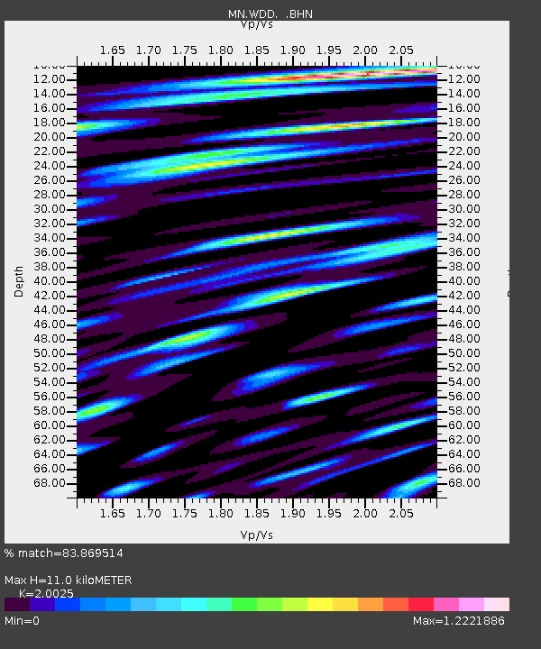
| Estimated Moho Depth: |
11.0 km |
| Estimated Crust Vp/Vs: |
2.00 |
| Assumed Crust Vp: |
4.05 km/s |
| Estimated Crust Vs: |
2.023 km/s |
| Estimated Crust Poisson's Ratio: |
0.33 |
|
| Radial Match: |
83.869514 % |
| Radial Bump: |
400 |
| Transverse Match: |
73.11995 % |
| Transverse Bump: |
400 |
| SOD ConfigId: |
2564 |
| Insert Time: |
2010-03-08 18:03:44.348 +0000 |
| GWidth: |
2.5 |
| Max Bumps: |
400 |
| Tol: |
0.001 |
|
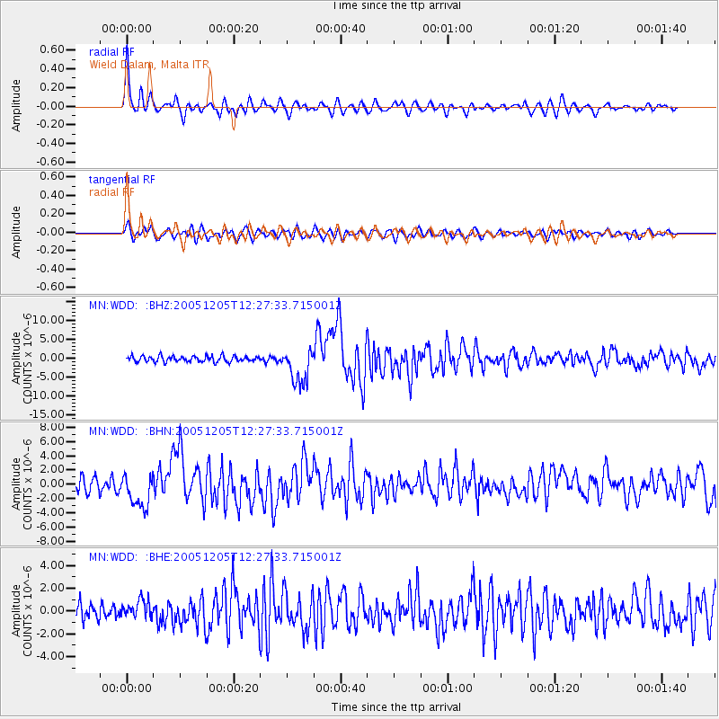
Signal To Noise
| Channel | StoN | STA | LTA |
| MN:WDD: :BHN:20051205T12:27:33.715001Z | 2.7447495 | 2.4435367E-6 | 8.9025855E-7 |
| MN:WDD: :BHE:20051205T12:27:33.715001Z | 1.1708201 | 8.0096584E-7 | 6.841067E-7 |
| MN:WDD: :BHZ:20051205T12:27:33.715001Z | 6.187866 | 4.753164E-6 | 7.681427E-7 |
| Arrivals |
| Ps | 2.8 SECOND |
| PpPs | 8.0 SECOND |
| PsPs/PpSs | 11 SECOND |


