You are here: Home > Network List > N4 - Central and EAstern US Network Stations List
> Station W59A Clinton, NC, USA > Earthquake Result Viewer
W59A Clinton, NC, USA - Earthquake Result Viewer
| Earthquake location: |
North Of Svalbard |
| Earthquake latitude/longitude: |
85.7/22.7 |
| Earthquake time(UTC): |
2020/02/18 (049) 07:29:39 GMT |
| Earthquake Depth: |
10 km |
| Earthquake Magnitude: |
5.2 Mww |
| Earthquake Catalog/Contributor: |
NEIC PDE/us |
|
| Network: |
N4 Central and EAstern US Network |
| Station: |
W59A Clinton, NC, USA |
| Lat/Lon: |
35.17 N/78.44 W |
| Elevation: |
60 m |
|
| Distance: |
55.9 deg |
| Az: |
284.023 deg |
| Baz: |
5.081 deg |
| Ray Param: |
0.06447294 |
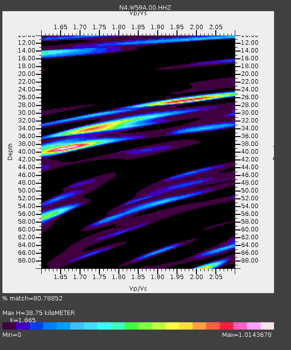
| Estimated Moho Depth: |
38.75 km |
| Estimated Crust Vp/Vs: |
1.66 |
| Assumed Crust Vp: |
6.565 km/s |
| Estimated Crust Vs: |
3.943 km/s |
| Estimated Crust Poisson's Ratio: |
0.22 |
|
| Radial Match: |
80.78852 % |
| Radial Bump: |
400 |
| Transverse Match: |
52.931202 % |
| Transverse Bump: |
400 |
| SOD ConfigId: |
20831131 |
| Insert Time: |
2020-03-15 22:24:11.275 +0000 |
| GWidth: |
2.5 |
| Max Bumps: |
400 |
| Tol: |
0.001 |
|

Signal To Noise
| Channel | StoN | STA | LTA |
| N4:W59A:00:HHZ:20200218T07:38:46.269974Z | 4.9365144 | 1.3508071E-6 | 2.736358E-7 |
| N4:W59A:00:HH1:20200218T07:38:46.269974Z | 3.2870233 | 8.332499E-7 | 2.534968E-7 |
| N4:W59A:00:HH2:20200218T07:38:46.269974Z | 1.3392676 | 3.3435265E-7 | 2.4965334E-7 |
| Arrivals |
| Ps | 4.2 SECOND |
| PpPs | 15 SECOND |
| PsPs/PpSs | 19 SECOND |


