You are here: Home > Network List > MN - MEDNET Project Stations List
> Station WDD Wield Dalam, Malta > Earthquake Result Viewer
WDD Wield Dalam, Malta - Earthquake Result Viewer
| Earthquake location: |
Salta Province, Argentina |
| Earthquake latitude/longitude: |
-25.0/-63.5 |
| Earthquake time(UTC): |
2005/03/21 (080) 12:23:54 GMT |
| Earthquake Depth: |
579 km |
| Earthquake Magnitude: |
6.1 MB, 6.9 MW, 6.9 MW |
| Earthquake Catalog/Contributor: |
WHDF/NEIC |
|
| Network: |
MN MEDNET Project |
| Station: |
WDD Wield Dalam, Malta |
| Lat/Lon: |
35.87 N/14.52 E |
| Elevation: |
41 m |
|
| Distance: |
95.3 deg |
| Az: |
52.923 deg |
| Baz: |
243.051 deg |
| Ray Param: |
0.040227316 |
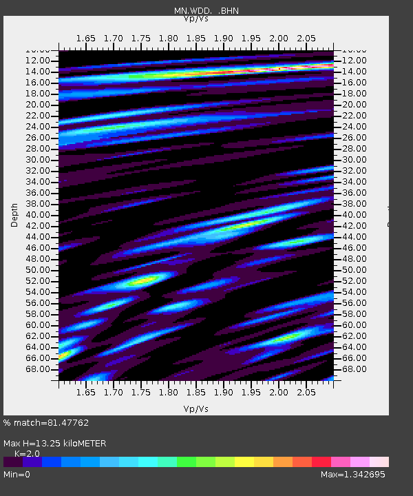
| Estimated Moho Depth: |
13.25 km |
| Estimated Crust Vp/Vs: |
2.00 |
| Assumed Crust Vp: |
4.05 km/s |
| Estimated Crust Vs: |
2.025 km/s |
| Estimated Crust Poisson's Ratio: |
0.33 |
|
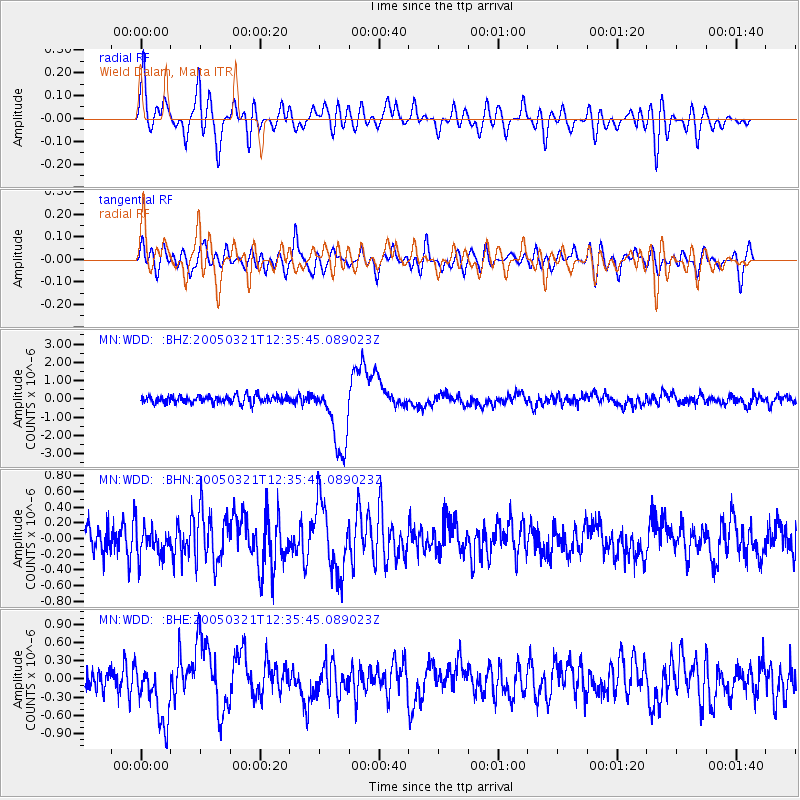
| Radial Match: |
81.47762 % |
| Radial Bump: |
400 |
| Transverse Match: |
72.657425 % |
| Transverse Bump: |
400 |
| SOD ConfigId: |
2459 |
| Insert Time: |
2010-03-08 18:03:45.497 +0000 |
| GWidth: |
2.5 |
| Max Bumps: |
400 |
| Tol: |
0.001 |
|
Signal To Noise
| Channel | StoN | STA | LTA |
| MN:WDD: :BHN:20050321T12:35:45.089023Z | 0.89317054 | 1.8364709E-7 | 2.0561257E-7 |
| MN:WDD: :BHE:20050321T12:35:45.089023Z | 2.3895102 | 4.849807E-7 | 2.029624E-7 |
| MN:WDD: :BHZ:20050321T12:35:45.089023Z | 9.187953 | 1.8580693E-6 | 2.0222886E-7 |
| Arrivals |
| Ps | 3.3 SECOND |
| PpPs | 9.7 SECOND |
| PsPs/PpSs | 13 SECOND |


