You are here: Home > Network List > NM - Cooperative New Madrid Seismic Network Stations List
> Station PENM Penman,Portageville,MO > Earthquake Result Viewer
PENM Penman,Portageville,MO - Earthquake Result Viewer
| Earthquake location: |
North Of Svalbard |
| Earthquake latitude/longitude: |
85.7/22.7 |
| Earthquake time(UTC): |
2020/02/18 (049) 07:29:39 GMT |
| Earthquake Depth: |
10 km |
| Earthquake Magnitude: |
5.2 Mww |
| Earthquake Catalog/Contributor: |
NEIC PDE/us |
|
| Network: |
NM Cooperative New Madrid Seismic Network |
| Station: |
PENM Penman,Portageville,MO |
| Lat/Lon: |
36.45 N/89.63 W |
| Elevation: |
85 m |
|
| Distance: |
55.5 deg |
| Az: |
295.12 deg |
| Baz: |
4.817 deg |
| Ray Param: |
0.06477743 |
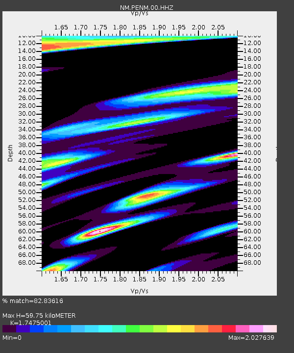
| Estimated Moho Depth: |
59.75 km |
| Estimated Crust Vp/Vs: |
1.75 |
| Assumed Crust Vp: |
6.444 km/s |
| Estimated Crust Vs: |
3.687 km/s |
| Estimated Crust Poisson's Ratio: |
0.26 |
|
| Radial Match: |
82.83616 % |
| Radial Bump: |
370 |
| Transverse Match: |
51.463028 % |
| Transverse Bump: |
397 |
| SOD ConfigId: |
20831131 |
| Insert Time: |
2020-03-15 22:30:35.965 +0000 |
| GWidth: |
2.5 |
| Max Bumps: |
400 |
| Tol: |
0.001 |
|

Signal To Noise
| Channel | StoN | STA | LTA |
| NM:PENM:00:HHZ:20200218T07:38:42.774979Z | 7.669026 | 2.3778393E-6 | 3.1005752E-7 |
| NM:PENM:00:HHN:20200218T07:38:42.774979Z | 3.376933 | 1.6245551E-6 | 4.8107415E-7 |
| NM:PENM:00:HHE:20200218T07:38:42.774979Z | 0.9561974 | 8.876844E-7 | 9.2834847E-7 |
| Arrivals |
| Ps | 7.3 SECOND |
| PpPs | 24 SECOND |
| PsPs/PpSs | 31 SECOND |


