You are here: Home > Network List > MN - MEDNET Project Stations List
> Station WDD Wield Dalam, Malta > Earthquake Result Viewer
WDD Wield Dalam, Malta - Earthquake Result Viewer
| Earthquake location: |
Western Brazil |
| Earthquake latitude/longitude: |
-8.1/-71.3 |
| Earthquake time(UTC): |
2007/07/21 (202) 13:27:04 GMT |
| Earthquake Depth: |
645 km |
| Earthquake Magnitude: |
6.2 MB, 6.1 MW, 6.0 MW |
| Earthquake Catalog/Contributor: |
WHDF/NEIC |
|
| Network: |
MN MEDNET Project |
| Station: |
WDD Wield Dalam, Malta |
| Lat/Lon: |
35.87 N/14.52 E |
| Elevation: |
41 m |
|
| Distance: |
91.3 deg |
| Az: |
54.122 deg |
| Baz: |
260.994 deg |
| Ray Param: |
0.04117899 |
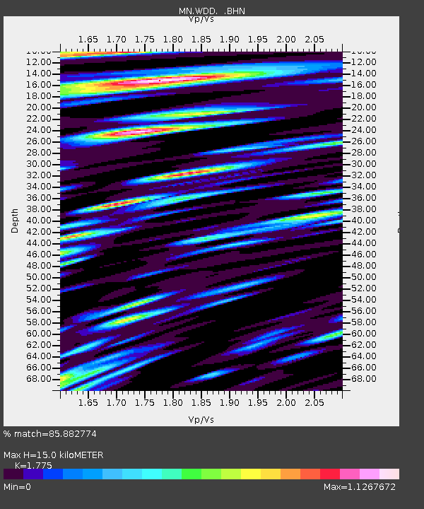
| Estimated Moho Depth: |
15.0 km |
| Estimated Crust Vp/Vs: |
1.77 |
| Assumed Crust Vp: |
4.05 km/s |
| Estimated Crust Vs: |
2.282 km/s |
| Estimated Crust Poisson's Ratio: |
0.27 |
|
| Radial Match: |
85.882774 % |
| Radial Bump: |
400 |
| Transverse Match: |
88.71557 % |
| Transverse Bump: |
400 |
| SOD ConfigId: |
2564 |
| Insert Time: |
2010-03-08 18:03:53.069 +0000 |
| GWidth: |
2.5 |
| Max Bumps: |
400 |
| Tol: |
0.001 |
|
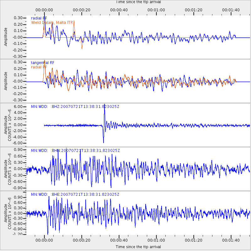
Signal To Noise
| Channel | StoN | STA | LTA |
| MN:WDD: :BHN:20070721T13:38:31.823025Z | 3.1443343 | 2.3893176E-7 | 7.5988034E-8 |
| MN:WDD: :BHE:20070721T13:38:31.823025Z | 6.0632753 | 4.3458613E-7 | 7.167514E-8 |
| MN:WDD: :BHZ:20070721T13:38:31.823025Z | 18.089804 | 2.0525272E-6 | 1.13463216E-7 |
| Arrivals |
| Ps | 2.9 SECOND |
| PpPs | 10 SECOND |
| PsPs/PpSs | 13 SECOND |


