You are here: Home > Network List > NN - Western Great Basin/Eastern Sierra Nevada Stations List
> Station DSP Deep Springs, California w84gm > Earthquake Result Viewer
DSP Deep Springs, California w84gm - Earthquake Result Viewer
| Earthquake location: |
North Of Svalbard |
| Earthquake latitude/longitude: |
85.7/22.7 |
| Earthquake time(UTC): |
2020/02/18 (049) 07:29:39 GMT |
| Earthquake Depth: |
10 km |
| Earthquake Magnitude: |
5.2 Mww |
| Earthquake Catalog/Contributor: |
NEIC PDE/us |
|
| Network: |
NN Western Great Basin/Eastern Sierra Nevada |
| Station: |
DSP Deep Springs, California w84gm |
| Lat/Lon: |
37.37 N/117.97 W |
| Elevation: |
1692 m |
|
| Distance: |
56.2 deg |
| Az: |
322.572 deg |
| Baz: |
3.27 deg |
| Ray Param: |
0.06432032 |
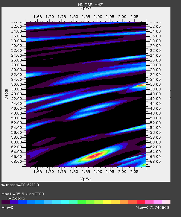
| Estimated Moho Depth: |
35.5 km |
| Estimated Crust Vp/Vs: |
2.10 |
| Assumed Crust Vp: |
6.279 km/s |
| Estimated Crust Vs: |
2.993 km/s |
| Estimated Crust Poisson's Ratio: |
0.35 |
|
| Radial Match: |
80.62119 % |
| Radial Bump: |
400 |
| Transverse Match: |
73.392204 % |
| Transverse Bump: |
400 |
| SOD ConfigId: |
20831131 |
| Insert Time: |
2020-03-15 22:32:18.780 +0000 |
| GWidth: |
2.5 |
| Max Bumps: |
400 |
| Tol: |
0.001 |
|

Signal To Noise
| Channel | StoN | STA | LTA |
| NN:DSP: :HHZ:20200218T07:38:47.927994Z | 8.458337 | 8.433576E-7 | 9.970726E-8 |
| NN:DSP: :HHN:20200218T07:38:47.927994Z | 3.304052 | 3.7319862E-7 | 1.12951795E-7 |
| NN:DSP: :HHE:20200218T07:38:47.927994Z | 1.7653973 | 2.2765092E-7 | 1.2895167E-7 |
| Arrivals |
| Ps | 6.5 SECOND |
| PpPs | 17 SECOND |
| PsPs/PpSs | 23 SECOND |


