You are here: Home > Network List > MN - MEDNET Project Stations List
> Station WDD Wield Dalam, Malta > Earthquake Result Viewer
WDD Wield Dalam, Malta - Earthquake Result Viewer
| Earthquake location: |
Sea Of Japan |
| Earthquake latitude/longitude: |
36.8/134.9 |
| Earthquake time(UTC): |
2007/07/16 (197) 14:17:37 GMT |
| Earthquake Depth: |
350 km |
| Earthquake Magnitude: |
6.2 MB, 6.8 MW, 6.8 MW |
| Earthquake Catalog/Contributor: |
WHDF/NEIC |
|
| Network: |
MN MEDNET Project |
| Station: |
WDD Wield Dalam, Malta |
| Lat/Lon: |
35.87 N/14.52 E |
| Elevation: |
41 m |
|
| Distance: |
88.9 deg |
| Az: |
315.475 deg |
| Baz: |
43.858 deg |
| Ray Param: |
0.041697223 |
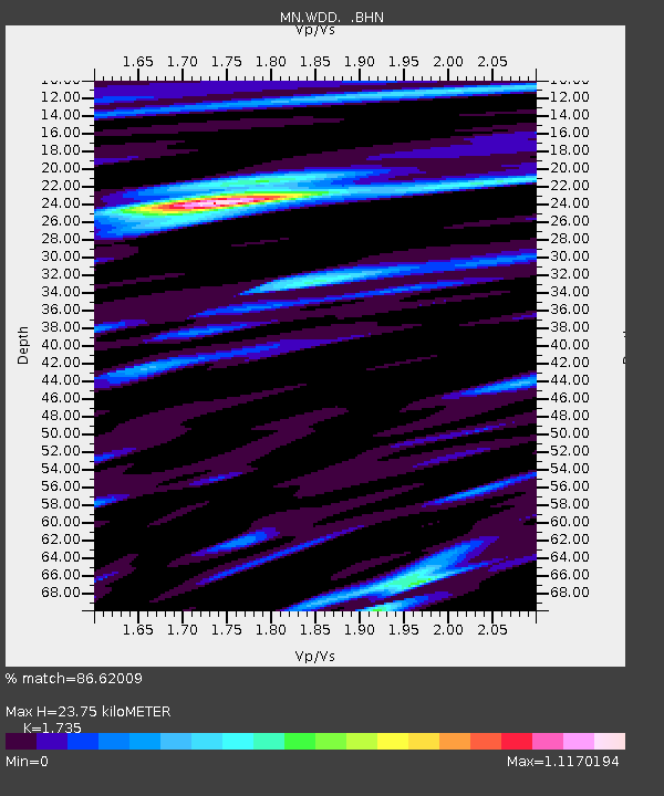
| Estimated Moho Depth: |
23.75 km |
| Estimated Crust Vp/Vs: |
1.74 |
| Assumed Crust Vp: |
4.05 km/s |
| Estimated Crust Vs: |
2.334 km/s |
| Estimated Crust Poisson's Ratio: |
0.25 |
|
| Radial Match: |
86.62009 % |
| Radial Bump: |
400 |
| Transverse Match: |
72.28255 % |
| Transverse Bump: |
400 |
| SOD ConfigId: |
2564 |
| Insert Time: |
2010-03-08 18:03:55.790 +0000 |
| GWidth: |
2.5 |
| Max Bumps: |
400 |
| Tol: |
0.001 |
|
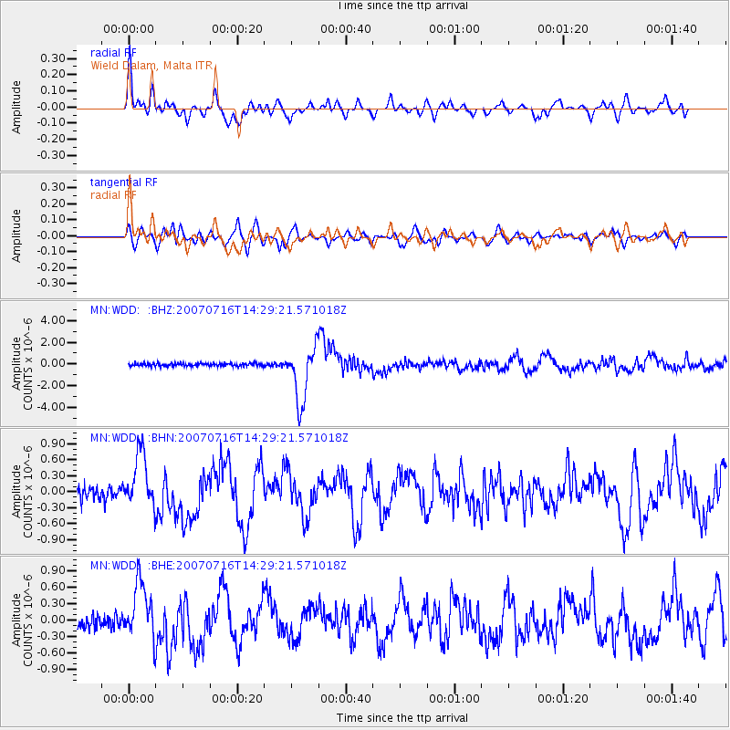
Signal To Noise
| Channel | StoN | STA | LTA |
| MN:WDD: :BHN:20070716T14:29:21.571018Z | 5.0998864 | 5.1797974E-7 | 1.0156691E-7 |
| MN:WDD: :BHE:20070716T14:29:21.571018Z | 4.7234797 | 5.1179575E-7 | 1.0835142E-7 |
| MN:WDD: :BHZ:20070716T14:29:21.571018Z | 18.923832 | 2.5340119E-6 | 1.3390586E-7 |
| Arrivals |
| Ps | 4.3 SECOND |
| PpPs | 16 SECOND |
| PsPs/PpSs | 20 SECOND |


