You are here: Home > Network List > MN - MEDNET Project Stations List
> Station WDD Wield Dalam, Malta > Earthquake Result Viewer
WDD Wield Dalam, Malta - Earthquake Result Viewer
| Earthquake location: |
Sea Of Okhotsk |
| Earthquake latitude/longitude: |
54.2/154.3 |
| Earthquake time(UTC): |
2008/11/24 (329) 09:02:58 GMT |
| Earthquake Depth: |
492 km |
| Earthquake Magnitude: |
6.5 MB, 7.3 MW, 7.3 MW |
| Earthquake Catalog/Contributor: |
WHDF/NEIC |
|
| Network: |
MN MEDNET Project |
| Station: |
WDD Wield Dalam, Malta |
| Lat/Lon: |
35.87 N/14.52 E |
| Elevation: |
41 m |
|
| Distance: |
83.8 deg |
| Az: |
328.174 deg |
| Baz: |
22.422 deg |
| Ray Param: |
0.044523906 |
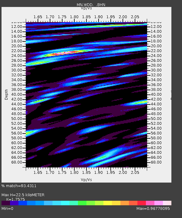
| Estimated Moho Depth: |
22.5 km |
| Estimated Crust Vp/Vs: |
1.76 |
| Assumed Crust Vp: |
4.05 km/s |
| Estimated Crust Vs: |
2.305 km/s |
| Estimated Crust Poisson's Ratio: |
0.26 |
|
| Radial Match: |
93.4311 % |
| Radial Bump: |
400 |
| Transverse Match: |
91.85414 % |
| Transverse Bump: |
400 |
| SOD ConfigId: |
2658 |
| Insert Time: |
2010-03-08 18:04:06.411 +0000 |
| GWidth: |
2.5 |
| Max Bumps: |
400 |
| Tol: |
0.001 |
|
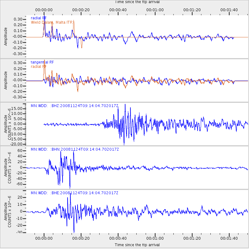
Signal To Noise
| Channel | StoN | STA | LTA |
| MN:WDD: :BHN:20081124T09:14:04.702017Z | 22.09231 | 1.1936609E-5 | 5.403061E-7 |
| MN:WDD: :BHE:20081124T09:14:04.702017Z | 6.252254 | 3.0288038E-6 | 4.844339E-7 |
| MN:WDD: :BHZ:20081124T09:14:04.702017Z | 3.3458636 | 1.7448576E-6 | 5.2149693E-7 |
| Arrivals |
| Ps | 4.2 SECOND |
| PpPs | 15 SECOND |
| PsPs/PpSs | 19 SECOND |


