You are here: Home > Network List > TS - TERRAscope (Southern California Seismic Network) Stations List
> Station PFO Pinon Flat, California, USA > Earthquake Result Viewer
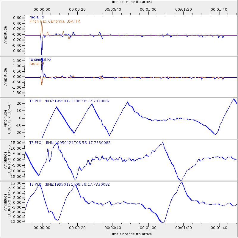
PFO Pinon Flat, California, USA - Earthquake Result Viewer
*The percent match for this event was below the threshold and hence no stack was calculated.
| Earthquake location: |
Kuril Islands |
| Earthquake latitude/longitude: |
43.3/146.7 |
| Earthquake time(UTC): |
1995/01/21 (021) 08:47:29 GMT |
| Earthquake Depth: |
63 km |
| Earthquake Magnitude: |
6.5 MB, 6.6 UNKNOWN, 6.4 MW |
| Earthquake Catalog/Contributor: |
WHDF/NEIC |
|
| Network: |
TS TERRAscope (Southern California Seismic Network) |
| Station: |
PFO Pinon Flat, California, USA |
| Lat/Lon: |
33.61 N/116.46 W |
| Elevation: |
1280 m |
|
| Distance: |
72.3 deg |
| Az: |
60.446 deg |
| Baz: |
310.487 deg |
| Ray Param: |
$rayparam |
*The percent match for this event was below the threshold and hence was not used in the summary stack. |
|
| Radial Match: |
95.410576 % |
| Radial Bump: |
247 |
| Transverse Match: |
98.305214 % |
| Transverse Bump: |
172 |
| SOD ConfigId: |
4480 |
| Insert Time: |
2010-02-26 14:43:20.621 +0000 |
| GWidth: |
2.5 |
| Max Bumps: |
400 |
| Tol: |
0.001 |
|
Signal To Noise
| Channel | StoN | STA | LTA |
| TS:PFO: :BHN:19950121T08:58:17.733008Z | 0.9475706 | 7.119409E-6 | 7.513328E-6 |
| TS:PFO: :BHE:19950121T08:58:17.733008Z | 1.1969155 | 8.372863E-6 | 6.9953667E-6 |
| TS:PFO: :BHZ:19950121T08:58:17.733008Z | 0.9670127 | 1.0533373E-5 | 1.0892693E-5 |
| Arrivals |
| Ps | |
| PpPs | |
| PsPs/PpSs | |


