You are here: Home > Network List > RV - Regional Alberta Seismic Observatory for Earthquake Studies Network Stations List
> Station EGLEA Eagle Lookout Tower, AB > Earthquake Result Viewer
EGLEA Eagle Lookout Tower, AB - Earthquake Result Viewer
| Earthquake location: |
North Of Svalbard |
| Earthquake latitude/longitude: |
85.7/22.7 |
| Earthquake time(UTC): |
2020/02/18 (049) 07:29:39 GMT |
| Earthquake Depth: |
10 km |
| Earthquake Magnitude: |
5.2 Mww |
| Earthquake Catalog/Contributor: |
NEIC PDE/us |
|
| Network: |
RV Regional Alberta Seismic Observatory for Earthquake Studies Network |
| Station: |
EGLEA Eagle Lookout Tower, AB |
| Lat/Lon: |
54.46 N/116.44 W |
| Elevation: |
1056 m |
|
| Distance: |
39.1 deg |
| Az: |
322.68 deg |
| Baz: |
4.453 deg |
| Ray Param: |
0.07522844 |
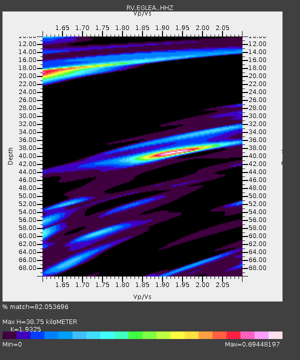
| Estimated Moho Depth: |
38.75 km |
| Estimated Crust Vp/Vs: |
1.93 |
| Assumed Crust Vp: |
6.426 km/s |
| Estimated Crust Vs: |
3.325 km/s |
| Estimated Crust Poisson's Ratio: |
0.32 |
|
| Radial Match: |
82.053696 % |
| Radial Bump: |
280 |
| Transverse Match: |
47.280327 % |
| Transverse Bump: |
400 |
| SOD ConfigId: |
20831131 |
| Insert Time: |
2020-03-15 23:28:46.117 +0000 |
| GWidth: |
2.5 |
| Max Bumps: |
400 |
| Tol: |
0.001 |
|

Signal To Noise
| Channel | StoN | STA | LTA |
| RV:EGLEA: :HHZ:20200218T07:36:35.189988Z | 13.561939 | 2.812034E-6 | 2.0734748E-7 |
| RV:EGLEA: :HHN:20200218T07:36:35.189988Z | 3.9008615 | 1.292229E-6 | 3.312676E-7 |
| RV:EGLEA: :HHE:20200218T07:36:35.189988Z | 1.3084986 | 5.320158E-7 | 4.0658492E-7 |
| Arrivals |
| Ps | 6.0 SECOND |
| PpPs | 17 SECOND |
| PsPs/PpSs | 23 SECOND |


