You are here: Home > Network List > GL - Volcanologic Seismologic Observatory Network of Guadeloupe -OVSG Stations List
> Station MML Mamelle > Earthquake Result Viewer
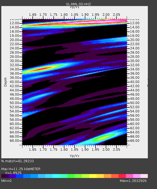
MML Mamelle - Earthquake Result Viewer
| Earthquake location: |
Southeastern Alaska |
| Earthquake latitude/longitude: |
59.9/-136.6 |
| Earthquake time(UTC): |
2017/05/01 (121) 12:31:53 GMT |
| Earthquake Depth: |
0.1 km |
| Earthquake Magnitude: |
6.5 Ml |
| Earthquake Catalog/Contributor: |
NEIC PDE/ak |
|
| Network: |
GL Volcanologic Seismologic Observatory Network of Guadeloupe -OVSG |
| Station: |
MML Mamelle |
| Lat/Lon: |
16.04 N/61.67 W |
| Elevation: |
1197 m |
|
| Distance: |
68.7 deg |
| Az: |
94.788 deg |
| Baz: |
328.474 deg |
| Ray Param: |
0.056165684 |
| Estimated Moho Depth: |
11.25 km |
| Estimated Crust Vp/Vs: |
1.95 |
| Assumed Crust Vp: |
6.048 km/s |
| Estimated Crust Vs: |
3.098 km/s |
| Estimated Crust Poisson's Ratio: |
0.32 |
|
| Radial Match: |
81.29233 % |
| Radial Bump: |
400 |
| Transverse Match: |
70.913994 % |
| Transverse Bump: |
400 |
| SOD ConfigId: |
2028011 |
| Insert Time: |
2017-05-15 12:35:50.651 +0000 |
| GWidth: |
2.5 |
| Max Bumps: |
400 |
| Tol: |
0.001 |
|

Signal To Noise
| Channel | StoN | STA | LTA |
| GL:MML:00:HHZ:20170501T12:42:27.210Z | 19.232548 | 1.0328639E-5 | 5.3703957E-7 |
| GL:MML:00:HHN:20170501T12:42:27.210Z | 7.293323 | 5.919693E-6 | 8.116593E-7 |
| GL:MML:00:HHE:20170501T12:42:27.210Z | 2.3912861 | 2.4749384E-6 | 1.0349821E-6 |
| Arrivals |
| Ps | 1.8 SECOND |
| PpPs | 5.3 SECOND |
| PsPs/PpSs | 7.2 SECOND |


