You are here: Home > Network List > TA - USArray Transportable Network (new EarthScope stations) Stations List
> Station K15K Wolf Creek Mountain, AK, USA > Earthquake Result Viewer
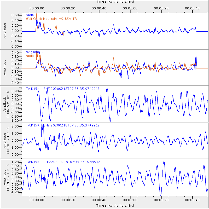
K15K Wolf Creek Mountain, AK, USA - Earthquake Result Viewer
*The percent match for this event was below the threshold and hence no stack was calculated.
| Earthquake location: |
North Of Svalbard |
| Earthquake latitude/longitude: |
85.7/22.7 |
| Earthquake time(UTC): |
2020/02/18 (049) 07:29:39 GMT |
| Earthquake Depth: |
10 km |
| Earthquake Magnitude: |
5.2 Mww |
| Earthquake Catalog/Contributor: |
NEIC PDE/us |
|
| Network: |
TA USArray Transportable Network (new EarthScope stations) |
| Station: |
K15K Wolf Creek Mountain, AK, USA |
| Lat/Lon: |
62.29 N/161.53 W |
| Elevation: |
346 m |
|
| Distance: |
32.1 deg |
| Az: |
3.715 deg |
| Baz: |
359.406 deg |
| Ray Param: |
$rayparam |
*The percent match for this event was below the threshold and hence was not used in the summary stack. |
|
| Radial Match: |
52.29367 % |
| Radial Bump: |
372 |
| Transverse Match: |
46.255154 % |
| Transverse Bump: |
400 |
| SOD ConfigId: |
20831131 |
| Insert Time: |
2020-03-15 23:44:19.463 +0000 |
| GWidth: |
2.5 |
| Max Bumps: |
400 |
| Tol: |
0.001 |
|
Signal To Noise
| Channel | StoN | STA | LTA |
| TA:K15K: :BHZ:20200218T07:35:35.974991Z | 3.0766394 | 1.2181663E-6 | 3.9594056E-7 |
| TA:K15K: :BHN:20200218T07:35:35.974991Z | 0.5457702 | 3.2014367E-7 | 5.865906E-7 |
| TA:K15K: :BHE:20200218T07:35:35.974991Z | 1.1168153 | 5.648323E-7 | 5.0575267E-7 |
| Arrivals |
| Ps | |
| PpPs | |
| PsPs/PpSs | |


