You are here: Home > Network List > TA - USArray Transportable Network (new EarthScope stations) Stations List
> Station K29M Barlow Dome, YT, CAN > Earthquake Result Viewer
K29M Barlow Dome, YT, CAN - Earthquake Result Viewer
| Earthquake location: |
North Of Svalbard |
| Earthquake latitude/longitude: |
85.7/22.7 |
| Earthquake time(UTC): |
2020/02/18 (049) 07:29:39 GMT |
| Earthquake Depth: |
10 km |
| Earthquake Magnitude: |
5.2 Mww |
| Earthquake Catalog/Contributor: |
NEIC PDE/us |
|
| Network: |
TA USArray Transportable Network (new EarthScope stations) |
| Station: |
K29M Barlow Dome, YT, CAN |
| Lat/Lon: |
63.84 N/137.52 W |
| Elevation: |
1367 m |
|
| Distance: |
30.4 deg |
| Az: |
342.746 deg |
| Baz: |
2.869 deg |
| Ray Param: |
0.079439394 |
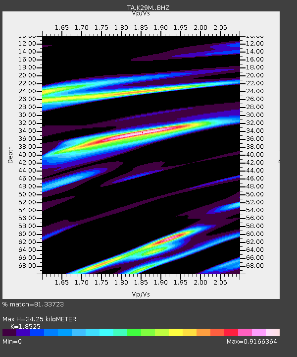
| Estimated Moho Depth: |
34.25 km |
| Estimated Crust Vp/Vs: |
1.85 |
| Assumed Crust Vp: |
6.566 km/s |
| Estimated Crust Vs: |
3.544 km/s |
| Estimated Crust Poisson's Ratio: |
0.29 |
|
| Radial Match: |
81.33723 % |
| Radial Bump: |
400 |
| Transverse Match: |
61.12913 % |
| Transverse Bump: |
365 |
| SOD ConfigId: |
20831131 |
| Insert Time: |
2020-03-15 23:44:30.486 +0000 |
| GWidth: |
2.5 |
| Max Bumps: |
400 |
| Tol: |
0.001 |
|
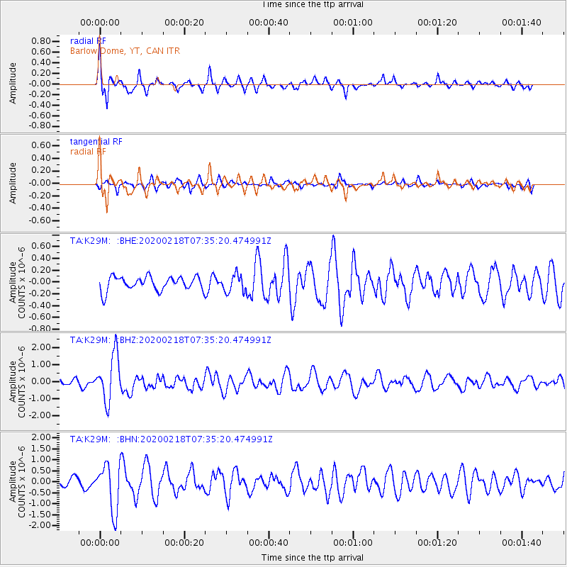
Signal To Noise
| Channel | StoN | STA | LTA |
| TA:K29M: :BHZ:20200218T07:35:20.474991Z | 6.883643 | 1.3895341E-6 | 2.0186027E-7 |
| TA:K29M: :BHN:20200218T07:35:20.474991Z | 5.9485874 | 1.0992322E-6 | 1.8478879E-7 |
| TA:K29M: :BHE:20200218T07:35:20.474991Z | 1.2809396 | 1.5266677E-7 | 1.1918343E-7 |
| Arrivals |
| Ps | 4.8 SECOND |
| PpPs | 14 SECOND |
| PsPs/PpSs | 19 SECOND |


