You are here: Home > Network List > TX - Texas Seismological Network Stations List
> Station PB05 Z > Earthquake Result Viewer
PB05 Z - Earthquake Result Viewer
| Earthquake location: |
North Of Svalbard |
| Earthquake latitude/longitude: |
85.7/22.7 |
| Earthquake time(UTC): |
2020/02/18 (049) 07:29:39 GMT |
| Earthquake Depth: |
10 km |
| Earthquake Magnitude: |
5.2 Mww |
| Earthquake Catalog/Contributor: |
NEIC PDE/us |
|
| Network: |
TX Texas Seismological Network |
| Station: |
PB05 Z |
| Lat/Lon: |
30.92 N/103.32 W |
| Elevation: |
957 m |
|
| Distance: |
61.8 deg |
| Az: |
307.96 deg |
| Baz: |
3.934 deg |
| Ray Param: |
0.060627308 |
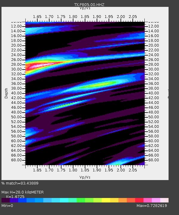
| Estimated Moho Depth: |
28.0 km |
| Estimated Crust Vp/Vs: |
1.67 |
| Assumed Crust Vp: |
6.121 km/s |
| Estimated Crust Vs: |
3.659 km/s |
| Estimated Crust Poisson's Ratio: |
0.22 |
|
| Radial Match: |
83.43889 % |
| Radial Bump: |
388 |
| Transverse Match: |
62.88126 % |
| Transverse Bump: |
400 |
| SOD ConfigId: |
20831131 |
| Insert Time: |
2020-03-16 00:02:02.465 +0000 |
| GWidth: |
2.5 |
| Max Bumps: |
400 |
| Tol: |
0.001 |
|

Signal To Noise
| Channel | StoN | STA | LTA |
| TX:PB05:00:HHZ:20200218T07:39:27.060013Z | 5.2870636 | 1.2792117E-6 | 2.4195126E-7 |
| TX:PB05:00:HH1:20200218T07:39:27.060013Z | 4.8572226 | 6.7253313E-7 | 1.3846044E-7 |
| TX:PB05:00:HH2:20200218T07:39:27.060013Z | 0.87385887 | 1.3359856E-7 | 1.5288344E-7 |
| Arrivals |
| Ps | 3.2 SECOND |
| PpPs | 12 SECOND |
| PsPs/PpSs | 15 SECOND |


