You are here: Home > Network List > GS - US Geological Survey Networks Stations List
> Station KAN08 Pence Farm, Harper, KS, USA > Earthquake Result Viewer
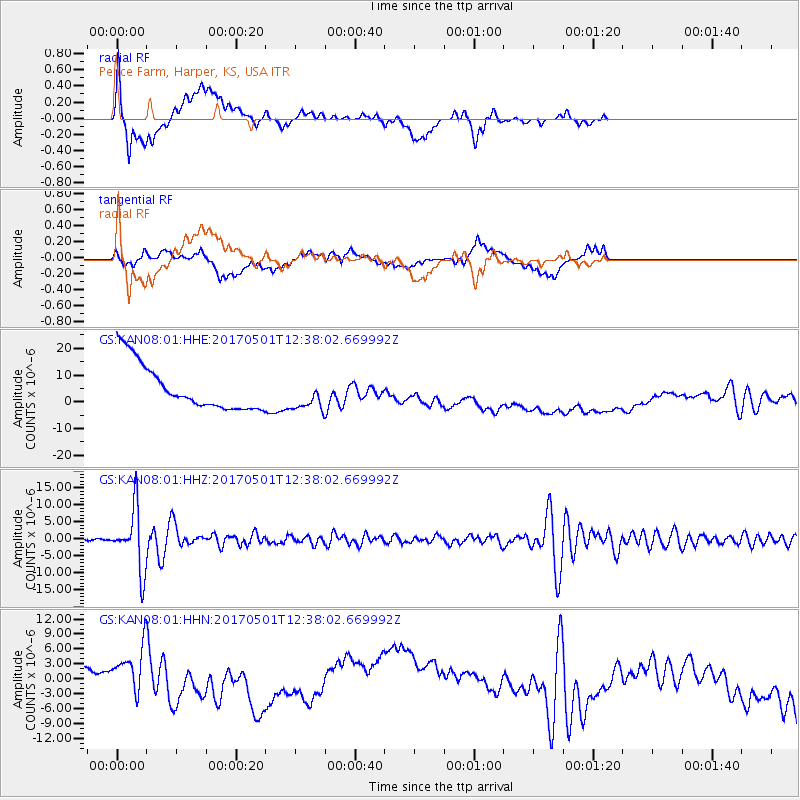
KAN08 Pence Farm, Harper, KS, USA - Earthquake Result Viewer
*The percent match for this event was below the threshold and hence no stack was calculated.
| Earthquake location: |
Southeastern Alaska |
| Earthquake latitude/longitude: |
59.9/-136.6 |
| Earthquake time(UTC): |
2017/05/01 (121) 12:31:53 GMT |
| Earthquake Depth: |
0.1 km |
| Earthquake Magnitude: |
6.5 Ml |
| Earthquake Catalog/Contributor: |
NEIC PDE/ak |
|
| Network: |
GS US Geological Survey Networks |
| Station: |
KAN08 Pence Farm, Harper, KS, USA |
| Lat/Lon: |
37.23 N/97.97 W |
| Elevation: |
375 m |
|
| Distance: |
33.4 deg |
| Az: |
115.24 deg |
| Baz: |
325.127 deg |
| Ray Param: |
$rayparam |
*The percent match for this event was below the threshold and hence was not used in the summary stack. |
|
| Radial Match: |
16.12765 % |
| Radial Bump: |
356 |
| Transverse Match: |
28.863476 % |
| Transverse Bump: |
400 |
| SOD ConfigId: |
2028011 |
| Insert Time: |
2017-05-15 12:36:24.771 +0000 |
| GWidth: |
2.5 |
| Max Bumps: |
400 |
| Tol: |
0.001 |
|
Signal To Noise
| Channel | StoN | STA | LTA |
| GS:KAN08:01:HHZ:20170501T12:38:02.669992Z | 43.926815 | 8.930704E-6 | 2.033087E-7 |
| GS:KAN08:01:HHN:20170501T12:38:02.669992Z | 1.0612619 | 7.765819E-6 | 7.3175333E-6 |
| GS:KAN08:01:HHE:20170501T12:38:02.669992Z | 0.70080775 | 6.0284633E-6 | 8.602165E-6 |
| Arrivals |
| Ps | |
| PpPs | |
| PsPs/PpSs | |


