You are here: Home > Network List > TX - Texas Seismological Network Stations List
> Station SGCY Sterling City > Earthquake Result Viewer
SGCY Sterling City - Earthquake Result Viewer
| Earthquake location: |
North Of Svalbard |
| Earthquake latitude/longitude: |
85.7/22.7 |
| Earthquake time(UTC): |
2020/02/18 (049) 07:29:39 GMT |
| Earthquake Depth: |
10 km |
| Earthquake Magnitude: |
5.2 Mww |
| Earthquake Catalog/Contributor: |
NEIC PDE/us |
|
| Network: |
TX Texas Seismological Network |
| Station: |
SGCY Sterling City |
| Lat/Lon: |
31.91 N/101.13 W |
| Elevation: |
776 m |
|
| Distance: |
60.7 deg |
| Az: |
305.901 deg |
| Baz: |
4.085 deg |
| Ray Param: |
0.061365765 |
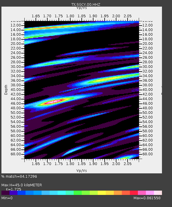
| Estimated Moho Depth: |
45.0 km |
| Estimated Crust Vp/Vs: |
1.73 |
| Assumed Crust Vp: |
6.38 km/s |
| Estimated Crust Vs: |
3.699 km/s |
| Estimated Crust Poisson's Ratio: |
0.25 |
|
| Radial Match: |
84.17296 % |
| Radial Bump: |
400 |
| Transverse Match: |
53.151993 % |
| Transverse Bump: |
400 |
| SOD ConfigId: |
20831131 |
| Insert Time: |
2020-03-16 00:04:20.378 +0000 |
| GWidth: |
2.5 |
| Max Bumps: |
400 |
| Tol: |
0.001 |
|

Signal To Noise
| Channel | StoN | STA | LTA |
| TX:SGCY:00:HHZ:20200218T07:39:19.479996Z | 8.17521 | 1.3408904E-6 | 1.6401908E-7 |
| TX:SGCY:00:HH1:20200218T07:39:19.479996Z | 0.75752795 | 1.5009807E-7 | 1.9814196E-7 |
| TX:SGCY:00:HH2:20200218T07:39:19.479996Z | 4.140432 | 6.514852E-7 | 1.5734716E-7 |
| Arrivals |
| Ps | 5.4 SECOND |
| PpPs | 18 SECOND |
| PsPs/PpSs | 24 SECOND |


