You are here: Home > Network List > TS - TERRAscope (Southern California Seismic Network) Stations List
> Station PFO Pinon Flat, California, USA > Earthquake Result Viewer
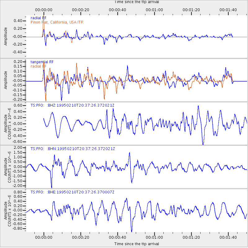
PFO Pinon Flat, California, USA - Earthquake Result Viewer
*The percent match for this event was below the threshold and hence no stack was calculated.
| Earthquake location: |
Chile-Bolivia Border Region |
| Earthquake latitude/longitude: |
-19.8/-68.5 |
| Earthquake time(UTC): |
1995/02/10 (041) 20:27:03 GMT |
| Earthquake Depth: |
164 km |
| Earthquake Magnitude: |
5.7 UNKNOWN, 5.4 MB, 5.7 MW |
| Earthquake Catalog/Contributor: |
WHDF/NEIC |
|
| Network: |
TS TERRAscope (Southern California Seismic Network) |
| Station: |
PFO Pinon Flat, California, USA |
| Lat/Lon: |
33.61 N/116.46 W |
| Elevation: |
1280 m |
|
| Distance: |
70.0 deg |
| Az: |
318.78 deg |
| Baz: |
131.959 deg |
| Ray Param: |
$rayparam |
*The percent match for this event was below the threshold and hence was not used in the summary stack. |
|
| Radial Match: |
69.1944 % |
| Radial Bump: |
400 |
| Transverse Match: |
68.79836 % |
| Transverse Bump: |
400 |
| SOD ConfigId: |
4480 |
| Insert Time: |
2010-02-26 14:43:22.169 +0000 |
| GWidth: |
2.5 |
| Max Bumps: |
400 |
| Tol: |
0.001 |
|
Signal To Noise
| Channel | StoN | STA | LTA |
| TS:PFO: :BHN:19950210T20:37:26.372021Z | 2.750019 | 6.6744144E-7 | 2.4270432E-7 |
| TS:PFO: :BHE:19950210T20:37:26.370007Z | 0.7262159 | 1.4619306E-7 | 2.01308E-7 |
| TS:PFO: :BHZ:19950210T20:37:26.372021Z | 0.87427026 | 1.589996E-7 | 1.818655E-7 |
| Arrivals |
| Ps | |
| PpPs | |
| PsPs/PpSs | |


