You are here: Home > Network List > GS - US Geological Survey Networks Stations List
> Station OK029 Liberty Lake, Oklahoma, USA > Earthquake Result Viewer
OK029 Liberty Lake, Oklahoma, USA - Earthquake Result Viewer
| Earthquake location: |
Southeastern Alaska |
| Earthquake latitude/longitude: |
59.9/-136.6 |
| Earthquake time(UTC): |
2017/05/01 (121) 12:31:53 GMT |
| Earthquake Depth: |
0.1 km |
| Earthquake Magnitude: |
6.5 Ml |
| Earthquake Catalog/Contributor: |
NEIC PDE/ak |
|
| Network: |
GS US Geological Survey Networks |
| Station: |
OK029 Liberty Lake, Oklahoma, USA |
| Lat/Lon: |
35.80 N/97.45 W |
| Elevation: |
333 m |
|
| Distance: |
34.8 deg |
| Az: |
116.065 deg |
| Baz: |
326.117 deg |
| Ray Param: |
0.07757232 |
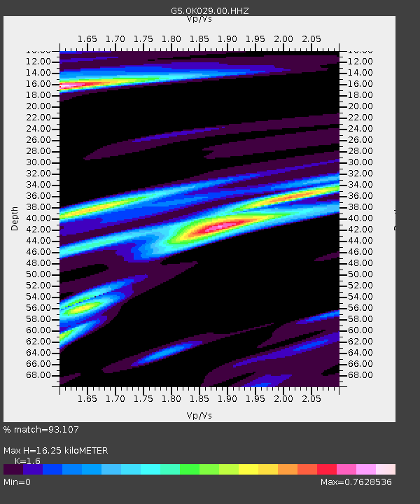
| Estimated Moho Depth: |
16.25 km |
| Estimated Crust Vp/Vs: |
1.60 |
| Assumed Crust Vp: |
6.426 km/s |
| Estimated Crust Vs: |
4.016 km/s |
| Estimated Crust Poisson's Ratio: |
0.18 |
|
| Radial Match: |
93.107 % |
| Radial Bump: |
220 |
| Transverse Match: |
76.212494 % |
| Transverse Bump: |
400 |
| SOD ConfigId: |
2028011 |
| Insert Time: |
2017-05-15 12:36:52.307 +0000 |
| GWidth: |
2.5 |
| Max Bumps: |
400 |
| Tol: |
0.001 |
|

Signal To Noise
| Channel | StoN | STA | LTA |
| GS:OK029:00:HHZ:20170501T12:38:14.904001Z | 58.30688 | 8.256189E-6 | 1.4159889E-7 |
| GS:OK029:00:HH1:20170501T12:38:14.904001Z | 14.50612 | 2.9436956E-6 | 2.0292784E-7 |
| GS:OK029:00:HH2:20170501T12:38:14.904001Z | 10.978461 | 2.6756707E-6 | 2.4372002E-7 |
| Arrivals |
| Ps | 1.7 SECOND |
| PpPs | 6.0 SECOND |
| PsPs/PpSs | 7.7 SECOND |


