You are here: Home > Network List > UW - Pacific Northwest Regional Seismic Network Stations List
> Station HOOD Mt Hood Meadows, OR CREST BB SMO > Earthquake Result Viewer
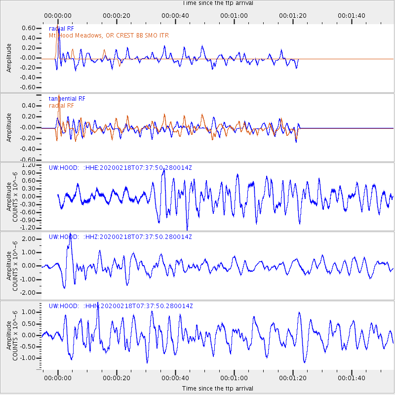
HOOD Mt Hood Meadows, OR CREST BB SMO - Earthquake Result Viewer
*The percent match for this event was below the threshold and hence no stack was calculated.
| Earthquake location: |
North Of Svalbard |
| Earthquake latitude/longitude: |
85.7/22.7 |
| Earthquake time(UTC): |
2020/02/18 (049) 07:29:39 GMT |
| Earthquake Depth: |
10 km |
| Earthquake Magnitude: |
5.2 Mww |
| Earthquake Catalog/Contributor: |
NEIC PDE/us |
|
| Network: |
UW Pacific Northwest Regional Seismic Network |
| Station: |
HOOD Mt Hood Meadows, OR CREST BB SMO |
| Lat/Lon: |
45.32 N/121.65 W |
| Elevation: |
1520 m |
|
| Distance: |
48.4 deg |
| Az: |
326.648 deg |
| Baz: |
3.341 deg |
| Ray Param: |
$rayparam |
*The percent match for this event was below the threshold and hence was not used in the summary stack. |
|
| Radial Match: |
67.891174 % |
| Radial Bump: |
400 |
| Transverse Match: |
60.22258 % |
| Transverse Bump: |
400 |
| SOD ConfigId: |
20831131 |
| Insert Time: |
2020-03-16 00:20:49.249 +0000 |
| GWidth: |
2.5 |
| Max Bumps: |
400 |
| Tol: |
0.001 |
|
Signal To Noise
| Channel | StoN | STA | LTA |
| UW:HOOD: :HHZ:20200218T07:37:50.280014Z | 4.8396525 | 1.1648228E-6 | 2.4068316E-7 |
| UW:HOOD: :HHN:20200218T07:37:50.280014Z | 2.4707522 | 5.2738176E-7 | 2.1344987E-7 |
| UW:HOOD: :HHE:20200218T07:37:50.280014Z | 2.2582974 | 4.2843777E-7 | 1.8971717E-7 |
| Arrivals |
| Ps | |
| PpPs | |
| PsPs/PpSs | |


