You are here: Home > Network List > TS - TERRAscope (Southern California Seismic Network) Stations List
> Station PFO Pinon Flat, California, USA > Earthquake Result Viewer
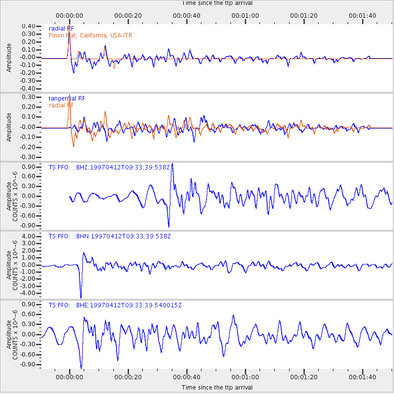
PFO Pinon Flat, California, USA - Earthquake Result Viewer
*The percent match for this event was below the threshold and hence no stack was calculated.
| Earthquake location: |
Kermadec Islands Region |
| Earthquake latitude/longitude: |
-28.2/-178.4 |
| Earthquake time(UTC): |
1997/04/12 (102) 09:21:56 GMT |
| Earthquake Depth: |
184 km |
| Earthquake Magnitude: |
5.8 MB, 6.0 UNKNOWN, 6.0 MW |
| Earthquake Catalog/Contributor: |
WHDF/NEIC |
|
| Network: |
TS TERRAscope (Southern California Seismic Network) |
| Station: |
PFO Pinon Flat, California, USA |
| Lat/Lon: |
33.61 N/116.46 W |
| Elevation: |
1280 m |
|
| Distance: |
84.9 deg |
| Az: |
47.658 deg |
| Baz: |
231.438 deg |
| Ray Param: |
$rayparam |
*The percent match for this event was below the threshold and hence was not used in the summary stack. |
|
| Radial Match: |
76.11156 % |
| Radial Bump: |
388 |
| Transverse Match: |
63.461796 % |
| Transverse Bump: |
386 |
| SOD ConfigId: |
4480 |
| Insert Time: |
2010-02-26 14:43:23.826 +0000 |
| GWidth: |
2.5 |
| Max Bumps: |
400 |
| Tol: |
0.001 |
|
Signal To Noise
| Channel | StoN | STA | LTA |
| TS:PFO: :BHN:19970412T09:33:39.538Z | 8.995983 | 1.4223435E-6 | 1.5810873E-7 |
| TS:PFO: :BHE:19970412T09:33:39.540015Z | 1.899386 | 3.9812178E-7 | 2.0960552E-7 |
| TS:PFO: :BHZ:19970412T09:33:39.538Z | 3.521085 | 3.4301576E-7 | 9.741763E-8 |
| Arrivals |
| Ps | |
| PpPs | |
| PsPs/PpSs | |


