You are here: Home > Network List > IU - Global Seismograph Network (GSN - IRIS/USGS) Stations List
> Station PMG Port Moresby, New Guinea > Earthquake Result Viewer
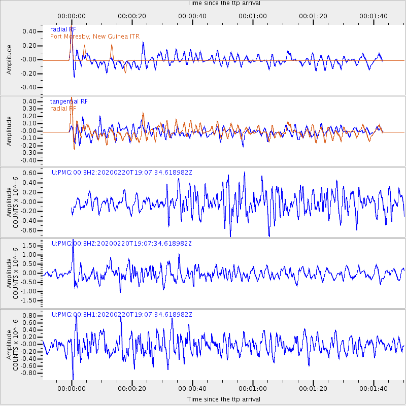
PMG Port Moresby, New Guinea - Earthquake Result Viewer
*The percent match for this event was below the threshold and hence no stack was calculated.
| Earthquake location: |
Near East Coast Of Kamchatka |
| Earthquake latitude/longitude: |
53.6/160.8 |
| Earthquake time(UTC): |
2020/02/20 (051) 18:57:36 GMT |
| Earthquake Depth: |
34 km |
| Earthquake Magnitude: |
5.7 Mwb |
| Earthquake Catalog/Contributor: |
NEIC PDE/us |
|
| Network: |
IU Global Seismograph Network (GSN - IRIS/USGS) |
| Station: |
PMG Port Moresby, New Guinea |
| Lat/Lon: |
9.40 S/147.16 E |
| Elevation: |
90 m |
|
| Distance: |
63.9 deg |
| Az: |
194.998 deg |
| Baz: |
8.984 deg |
| Ray Param: |
$rayparam |
*The percent match for this event was below the threshold and hence was not used in the summary stack. |
|
| Radial Match: |
63.783405 % |
| Radial Bump: |
400 |
| Transverse Match: |
52.875225 % |
| Transverse Bump: |
400 |
| SOD ConfigId: |
20831131 |
| Insert Time: |
2020-03-19 06:32:24.224 +0000 |
| GWidth: |
2.5 |
| Max Bumps: |
400 |
| Tol: |
0.001 |
|
Signal To Noise
| Channel | StoN | STA | LTA |
| IU:PMG:00:BHZ:20200220T19:07:34.618982Z | 3.406821 | 5.866762E-7 | 1.7220634E-7 |
| IU:PMG:00:BH1:20200220T19:07:34.618982Z | 3.2563877 | 3.8676265E-7 | 1.1877045E-7 |
| IU:PMG:00:BH2:20200220T19:07:34.618982Z | 1.3216883 | 1.5913474E-7 | 1.2040263E-7 |
| Arrivals |
| Ps | |
| PpPs | |
| PsPs/PpSs | |


