You are here: Home > Network List > IU - Global Seismograph Network (GSN - IRIS/USGS) Stations List
> Station RSSD Black Hills, South Dakota, USA > Earthquake Result Viewer
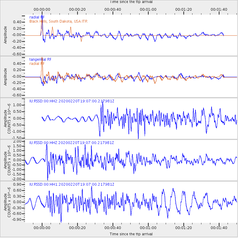
RSSD Black Hills, South Dakota, USA - Earthquake Result Viewer
*The percent match for this event was below the threshold and hence no stack was calculated.
| Earthquake location: |
Near East Coast Of Kamchatka |
| Earthquake latitude/longitude: |
53.6/160.8 |
| Earthquake time(UTC): |
2020/02/20 (051) 18:57:36 GMT |
| Earthquake Depth: |
34 km |
| Earthquake Magnitude: |
5.7 Mwb |
| Earthquake Catalog/Contributor: |
NEIC PDE/us |
|
| Network: |
IU Global Seismograph Network (GSN - IRIS/USGS) |
| Station: |
RSSD Black Hills, South Dakota, USA |
| Lat/Lon: |
44.12 N/104.04 W |
| Elevation: |
2090 m |
|
| Distance: |
58.8 deg |
| Az: |
57.02 deg |
| Baz: |
316.086 deg |
| Ray Param: |
$rayparam |
*The percent match for this event was below the threshold and hence was not used in the summary stack. |
|
| Radial Match: |
78.91639 % |
| Radial Bump: |
400 |
| Transverse Match: |
60.33348 % |
| Transverse Bump: |
400 |
| SOD ConfigId: |
20831131 |
| Insert Time: |
2020-03-19 06:32:57.302 +0000 |
| GWidth: |
2.5 |
| Max Bumps: |
400 |
| Tol: |
0.001 |
|
Signal To Noise
| Channel | StoN | STA | LTA |
| IU:RSSD:00:HHZ:20200220T19:07:00.217981Z | 4.2407827 | 7.778258E-7 | 1.8341561E-7 |
| IU:RSSD:00:HH1:20200220T19:07:00.217981Z | 1.3790338 | 2.3474949E-7 | 1.7022751E-7 |
| IU:RSSD:00:HH2:20200220T19:07:00.217981Z | 4.980497 | 5.915313E-7 | 1.1876954E-7 |
| Arrivals |
| Ps | |
| PpPs | |
| PsPs/PpSs | |


