You are here: Home > Network List > TS - TERRAscope (Southern California Seismic Network) Stations List
> Station PFO Pinon Flat, California, USA > Earthquake Result Viewer
PFO Pinon Flat, California, USA - Earthquake Result Viewer
*The percent match for this event was below the threshold and hence no stack was calculated.
| Earthquake location: |
Vanuatu Islands |
| Earthquake latitude/longitude: |
-13.7/166.5 |
| Earthquake time(UTC): |
1997/04/21 (111) 12:23:46 GMT |
| Earthquake Depth: |
33 km |
| Earthquake Magnitude: |
5.5 MB |
| Earthquake Catalog/Contributor: |
WHDF/NEIC |
|
| Network: |
TS TERRAscope (Southern California Seismic Network) |
| Station: |
PFO Pinon Flat, California, USA |
| Lat/Lon: |
33.61 N/116.46 W |
| Elevation: |
1280 m |
|
| Distance: |
87.0 deg |
| Az: |
54.542 deg |
| Baz: |
251.573 deg |
| Ray Param: |
$rayparam |
*The percent match for this event was below the threshold and hence was not used in the summary stack. |
|
| Radial Match: |
67.80053 % |
| Radial Bump: |
400 |
| Transverse Match: |
67.97038 % |
| Transverse Bump: |
400 |
| SOD ConfigId: |
4480 |
| Insert Time: |
2010-02-26 14:43:26.012 +0000 |
| GWidth: |
2.5 |
| Max Bumps: |
400 |
| Tol: |
0.001 |
|
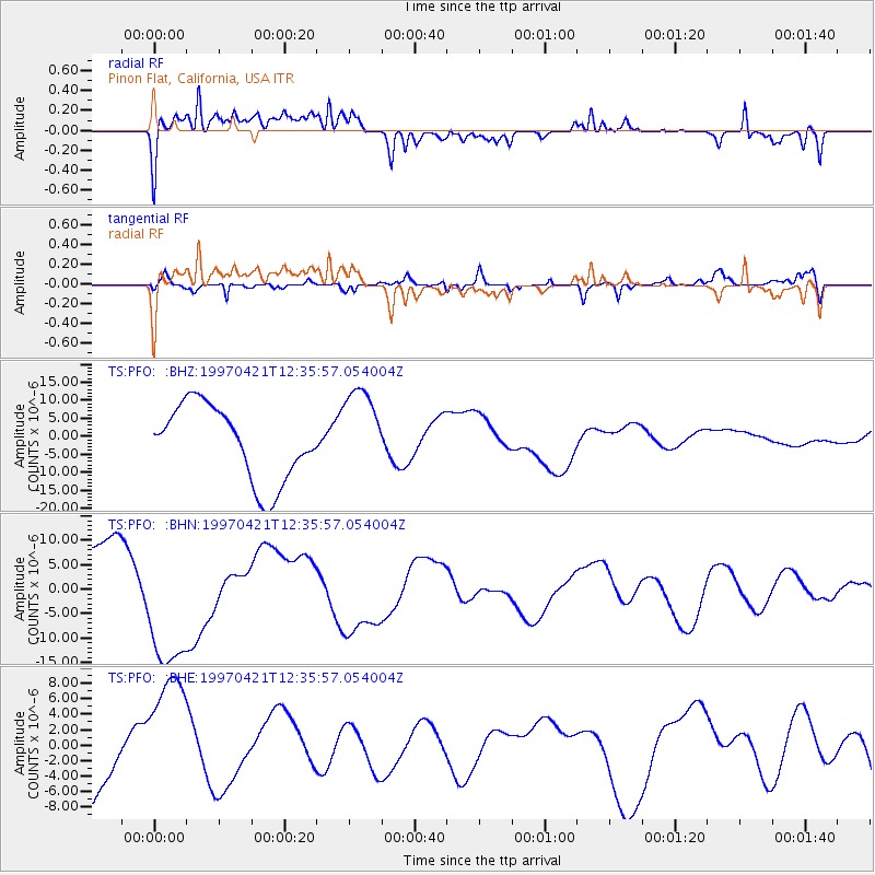
Signal To Noise
| Channel | StoN | STA | LTA |
| TS:PFO: :BHN:19970421T12:35:57.054004Z | 1.4412793 | 1.4171377E-5 | 9.832499E-6 |
| TS:PFO: :BHE:19970421T12:35:57.054004Z | 1.8229693 | 8.5638285E-6 | 4.6977357E-6 |
| TS:PFO: :BHZ:19970421T12:35:57.054004Z | 1.1858436 | 1.2365308E-5 | 1.0427436E-5 |
| Arrivals |
| Ps | |
| PpPs | |
| PsPs/PpSs | |


