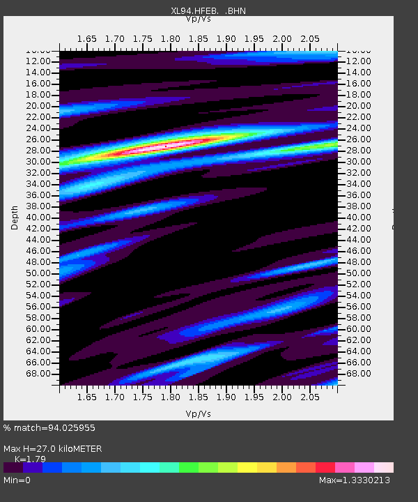
HFEB Harrisburg Flat east 11 - Earthquake Result Viewer
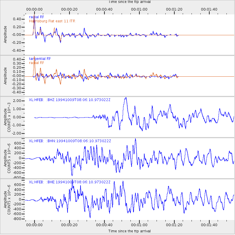
Earthquake location: Kuril Islands
Earthquake latitude/longitude: 43.9/147.9
Earthquake time(UTC): 1994/10/09 (282) 07:55:38 GMT
Earthquake Depth: 23 km
Earthquake Magnitude: 6.5 MB, 7.0 MS, 6.7 UNKNOWN, 7.3 MW
Earthquake Catalog/Contributor: WHDF/NEIC
Network: XL Southern Seirra - Death Valley
Station: HFEB Harrisburg Flat east 11
Lat/Lon: 36.36 N/117.08 W
Elevation: 1650 m
Distance: 69.1 deg
Az: 59.403 deg
Baz: 309.569 deg
Ray Param: 0.055847075
Estimated Moho Depth: 27.0 km
Estimated Crust Vp/Vs: 1.79
Assumed Crust Vp: 6.279 km/s
Estimated Crust Vs: 3.508 km/s
Estimated Crust Poisson's Ratio: 0.27
Radial Match: 94.025955 %
Radial Bump: 400
Transverse Match: 76.08936 %
Transverse Bump: 400
SOD ConfigId: 17000
Insert Time: 2010-03-08 18:06:27.682 +0000
GWidth: 2.5
Max Bumps: 400
Tol: 0.001

Signal To Noise

ChannelStoNSTALTA
XL:HFEB: :BHN:19941009T08:06:10.973022Z2.58890443.2983527E-51.2740342E-5
XL:HFEB: :BHE:19941009T08:06:10.973022Z1.59655483.940196E-52.4679366E-5
XL:HFEB: :BHZ:19941009T08:06:10.973022Z3.20015347.83927E-52.4496545E-5
Arrivals
Ps3.5 SECOND
PpPs12 SECOND
PsPs/PpSs15 SECOND