You are here: Home > Network List > XL94 - Southern Seirra - Death Valley Stations List
> Station HFEB Harrisburg Flat east 11 > Earthquake Result Viewer
HFEB Harrisburg Flat east 11 - Earthquake Result Viewer
| Earthquake location: |
East Of Kuril Islands |
| Earthquake latitude/longitude: |
43.8/148.1 |
| Earthquake time(UTC): |
1994/10/09 (282) 08:48:54 GMT |
| Earthquake Depth: |
35 km |
| Earthquake Magnitude: |
5.8 MB |
| Earthquake Catalog/Contributor: |
WHDF/NEIC |
|
| Network: |
XL Southern Seirra - Death Valley |
| Station: |
HFEB Harrisburg Flat east 11 |
| Lat/Lon: |
36.36 N/117.08 W |
| Elevation: |
1650 m |
|
| Distance: |
69.0 deg |
| Az: |
59.466 deg |
| Baz: |
309.43 deg |
| Ray Param: |
0.05585917 |
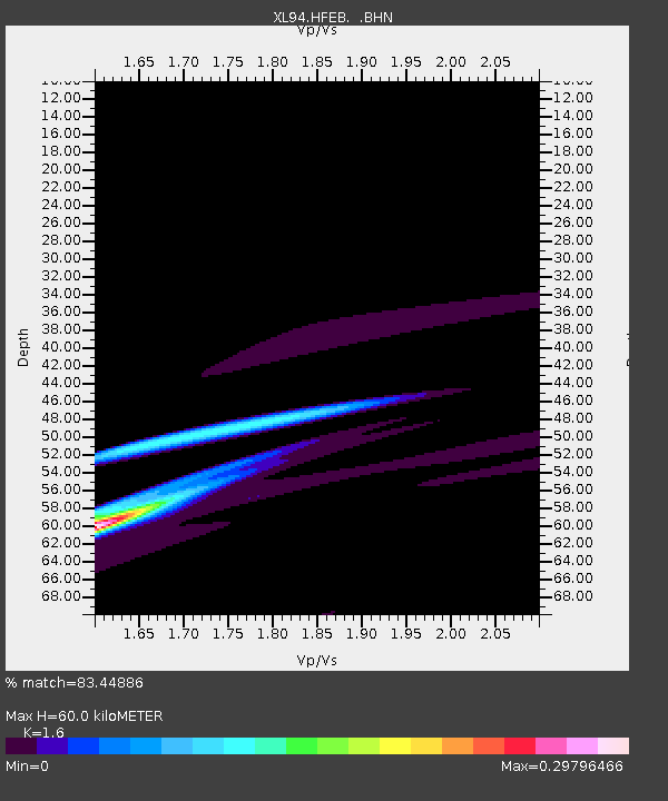
| Estimated Moho Depth: |
60.0 km |
| Estimated Crust Vp/Vs: |
1.60 |
| Assumed Crust Vp: |
6.279 km/s |
| Estimated Crust Vs: |
3.924 km/s |
| Estimated Crust Poisson's Ratio: |
0.18 |
|
| Radial Match: |
83.44886 % |
| Radial Bump: |
400 |
| Transverse Match: |
64.33701 % |
| Transverse Bump: |
400 |
| SOD ConfigId: |
17000 |
| Insert Time: |
2010-03-08 18:06:28.519 +0000 |
| GWidth: |
2.5 |
| Max Bumps: |
400 |
| Tol: |
0.001 |
|

Signal To Noise
| Channel | StoN | STA | LTA |
| XL:HFEB: :BHN:19941009T08:59:26.131995Z | 1.709076 | 0.0012357787 | 7.230683E-4 |
| XL:HFEB: :BHE:19941009T08:59:26.131995Z | 0.9867734 | 8.483132E-4 | 8.5968396E-4 |
| XL:HFEB: :BHZ:19941009T08:59:26.131995Z | 1.2681775 | 8.1597577E-4 | 6.434239E-4 |
| Arrivals |
| Ps | 6.0 SECOND |
| PpPs | 24 SECOND |
| PsPs/PpSs | 30 SECOND |


