You are here: Home > Network List > TS - TERRAscope (Southern California Seismic Network) Stations List
> Station PFO Pinon Flat, California, USA > Earthquake Result Viewer
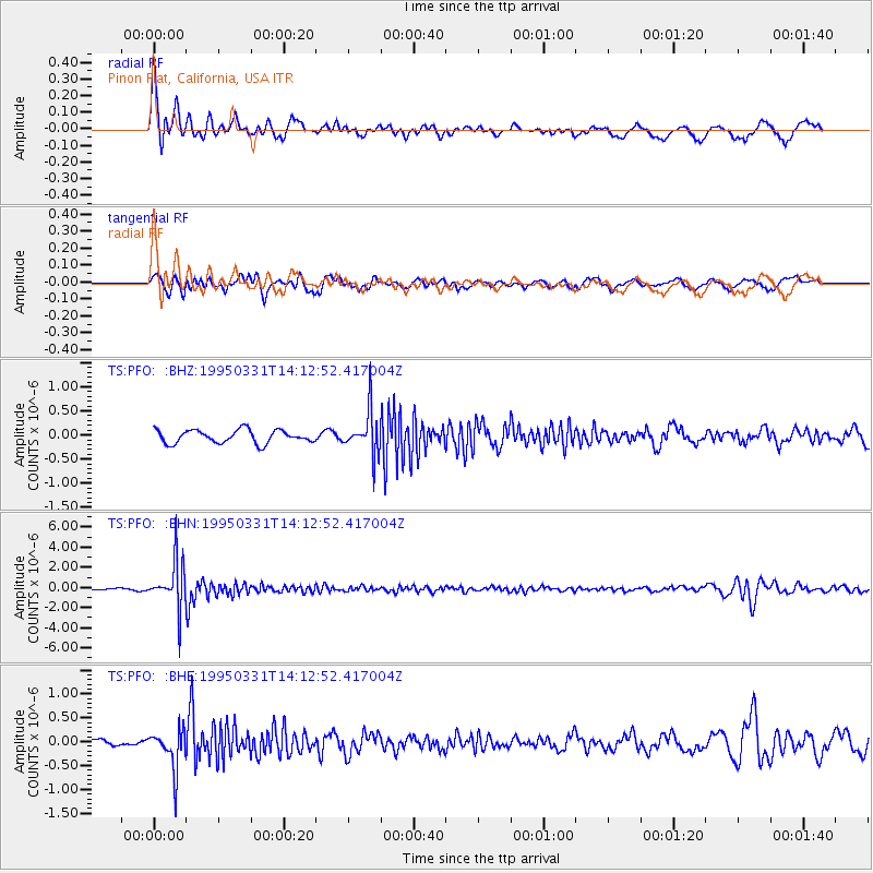
PFO Pinon Flat, California, USA - Earthquake Result Viewer
*The percent match for this event was below the threshold and hence no stack was calculated.
| Earthquake location: |
Sea Of Japan |
| Earthquake latitude/longitude: |
38.2/135.1 |
| Earthquake time(UTC): |
1995/03/31 (090) 14:01:40 GMT |
| Earthquake Depth: |
365 km |
| Earthquake Magnitude: |
6.0 MB, 6.2 UNKNOWN, 6.3 MW |
| Earthquake Catalog/Contributor: |
WHDF/NEIC |
|
| Network: |
TS TERRAscope (Southern California Seismic Network) |
| Station: |
PFO Pinon Flat, California, USA |
| Lat/Lon: |
33.61 N/116.46 W |
| Elevation: |
1280 m |
|
| Distance: |
82.5 deg |
| Az: |
52.966 deg |
| Baz: |
311.049 deg |
| Ray Param: |
$rayparam |
*The percent match for this event was below the threshold and hence was not used in the summary stack. |
|
| Radial Match: |
79.40181 % |
| Radial Bump: |
400 |
| Transverse Match: |
74.15873 % |
| Transverse Bump: |
400 |
| SOD ConfigId: |
4480 |
| Insert Time: |
2010-02-26 14:43:28.059 +0000 |
| GWidth: |
2.5 |
| Max Bumps: |
400 |
| Tol: |
0.001 |
|
Signal To Noise
| Channel | StoN | STA | LTA |
| TS:PFO: :BHN:19950331T14:12:52.417004Z | 36.53868 | 2.3988719E-6 | 6.565294E-8 |
| TS:PFO: :BHE:19950331T14:12:52.417004Z | 5.0095773 | 4.2734845E-7 | 8.530629E-8 |
| TS:PFO: :BHZ:19950331T14:12:52.417004Z | 3.4017348 | 4.5499084E-7 | 1.337526E-7 |
| Arrivals |
| Ps | |
| PpPs | |
| PsPs/PpSs | |


