You are here: Home > Network List > NM - Cooperative New Madrid Seismic Network Stations List
> Station HENM Henderson Mound,MO > Earthquake Result Viewer
HENM Henderson Mound,MO - Earthquake Result Viewer
| Earthquake location: |
Southeastern Alaska |
| Earthquake latitude/longitude: |
59.9/-136.6 |
| Earthquake time(UTC): |
2017/05/01 (121) 12:31:53 GMT |
| Earthquake Depth: |
0.1 km |
| Earthquake Magnitude: |
6.5 Ml |
| Earthquake Catalog/Contributor: |
NEIC PDE/ak |
|
| Network: |
NM Cooperative New Madrid Seismic Network |
| Station: |
HENM Henderson Mound,MO |
| Lat/Lon: |
36.72 N/89.47 W |
| Elevation: |
88 m |
|
| Distance: |
37.8 deg |
| Az: |
106.291 deg |
| Baz: |
322.937 deg |
| Ray Param: |
0.07594644 |
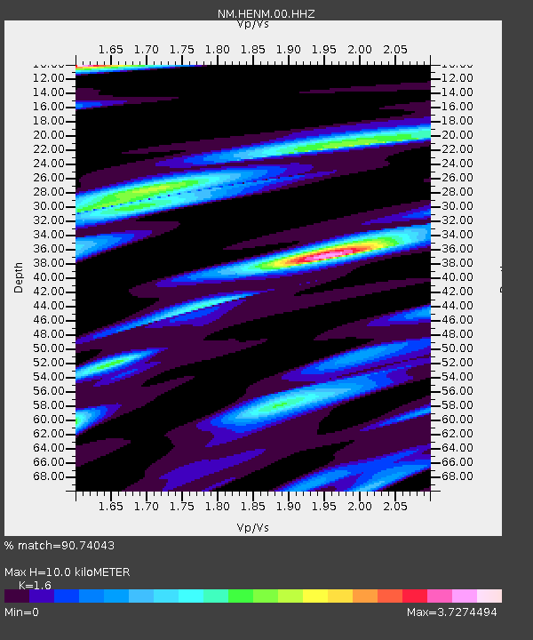
| Estimated Moho Depth: |
10.0 km |
| Estimated Crust Vp/Vs: |
1.60 |
| Assumed Crust Vp: |
6.444 km/s |
| Estimated Crust Vs: |
4.027 km/s |
| Estimated Crust Poisson's Ratio: |
0.18 |
|
| Radial Match: |
90.74043 % |
| Radial Bump: |
296 |
| Transverse Match: |
85.44878 % |
| Transverse Bump: |
345 |
| SOD ConfigId: |
2028011 |
| Insert Time: |
2017-05-15 12:42:05.818 +0000 |
| GWidth: |
2.5 |
| Max Bumps: |
400 |
| Tol: |
0.001 |
|

Signal To Noise
| Channel | StoN | STA | LTA |
| NM:HENM:00:HHZ:20170501T12:38:40.555002Z | 17.799973 | 9.309901E-6 | 5.230289E-7 |
| NM:HENM:00:HHN:20170501T12:38:40.555002Z | 10.587366 | 9.790104E-6 | 9.246968E-7 |
| NM:HENM:00:HHE:20170501T12:38:40.555002Z | 8.6855345 | 7.140421E-6 | 8.22105E-7 |
| Arrivals |
| Ps | 1.0 SECOND |
| PpPs | 3.7 SECOND |
| PsPs/PpSs | 4.7 SECOND |


