You are here: Home > Network List > US - United States National Seismic Network Stations List
> Station WMOK Wichita Mountains, Oklahoma, USA > Earthquake Result Viewer
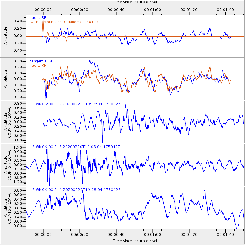
WMOK Wichita Mountains, Oklahoma, USA - Earthquake Result Viewer
*The percent match for this event was below the threshold and hence no stack was calculated.
| Earthquake location: |
Near East Coast Of Kamchatka |
| Earthquake latitude/longitude: |
53.6/160.8 |
| Earthquake time(UTC): |
2020/02/20 (051) 18:57:36 GMT |
| Earthquake Depth: |
34 km |
| Earthquake Magnitude: |
5.7 Mwb |
| Earthquake Catalog/Contributor: |
NEIC PDE/us |
|
| Network: |
US United States National Seismic Network |
| Station: |
WMOK Wichita Mountains, Oklahoma, USA |
| Lat/Lon: |
34.74 N/98.78 W |
| Elevation: |
486 m |
|
| Distance: |
68.5 deg |
| Az: |
60.529 deg |
| Baz: |
320.988 deg |
| Ray Param: |
$rayparam |
*The percent match for this event was below the threshold and hence was not used in the summary stack. |
|
| Radial Match: |
38.2758 % |
| Radial Bump: |
400 |
| Transverse Match: |
32.438347 % |
| Transverse Bump: |
400 |
| SOD ConfigId: |
20831131 |
| Insert Time: |
2020-03-19 08:59:08.639 +0000 |
| GWidth: |
2.5 |
| Max Bumps: |
400 |
| Tol: |
0.001 |
|
Signal To Noise
| Channel | StoN | STA | LTA |
| US:WMOK:00:BHZ:20200220T19:08:04.175012Z | 3.8056324 | 6.2757704E-7 | 1.6490743E-7 |
| US:WMOK:00:BH1:20200220T19:08:04.175012Z | 1.6662846 | 4.2280487E-7 | 2.537411E-7 |
| US:WMOK:00:BH2:20200220T19:08:04.175012Z | 2.2411704 | 3.8339394E-7 | 1.7106862E-7 |
| Arrivals |
| Ps | |
| PpPs | |
| PsPs/PpSs | |


