You are here: Home > Network List > UU - University of Utah Regional Network Stations List
> Station FORU South Mineral Mountains, UT, USA > Earthquake Result Viewer
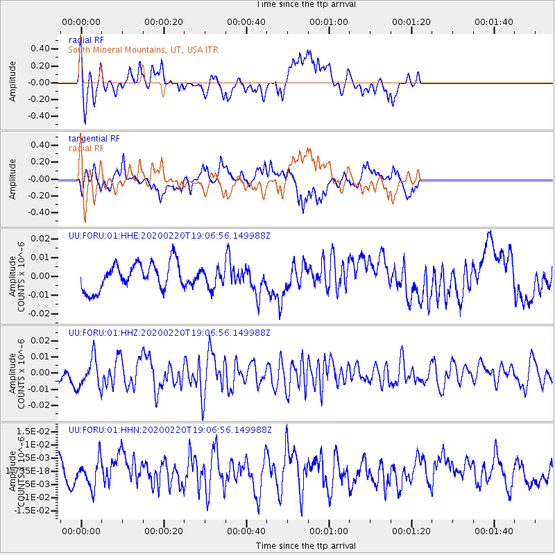
FORU South Mineral Mountains, UT, USA - Earthquake Result Viewer
*The percent match for this event was below the threshold and hence no stack was calculated.
| Earthquake location: |
Near East Coast Of Kamchatka |
| Earthquake latitude/longitude: |
53.6/160.8 |
| Earthquake time(UTC): |
2020/02/20 (051) 18:57:36 GMT |
| Earthquake Depth: |
34 km |
| Earthquake Magnitude: |
5.7 Mwb |
| Earthquake Catalog/Contributor: |
NEIC PDE/us |
|
| Network: |
UU University of Utah Regional Network |
| Station: |
FORU South Mineral Mountains, UT, USA |
| Lat/Lon: |
38.46 N/112.86 W |
| Elevation: |
1840 m |
|
| Distance: |
58.2 deg |
| Az: |
67.234 deg |
| Baz: |
315.622 deg |
| Ray Param: |
$rayparam |
*The percent match for this event was below the threshold and hence was not used in the summary stack. |
|
| Radial Match: |
67.03914 % |
| Radial Bump: |
329 |
| Transverse Match: |
64.722595 % |
| Transverse Bump: |
308 |
| SOD ConfigId: |
20831131 |
| Insert Time: |
2020-03-19 09:00:40.587 +0000 |
| GWidth: |
2.5 |
| Max Bumps: |
400 |
| Tol: |
0.001 |
|
Signal To Noise
| Channel | StoN | STA | LTA |
| UU:FORU:01:HHZ:20200220T19:06:56.149988Z | 2.5964382 | 9.0585806E-9 | 3.488849E-9 |
| UU:FORU:01:HHN:20200220T19:06:56.149988Z | 1.0939573 | 5.4197145E-9 | 4.9542286E-9 |
| UU:FORU:01:HHE:20200220T19:06:56.149988Z | 0.7030089 | 5.0067923E-9 | 7.1219475E-9 |
| Arrivals |
| Ps | |
| PpPs | |
| PsPs/PpSs | |


