You are here: Home > Network List > OK - Oklahoma Seismic Network Stations List
> Station FNO Franklin, Norman, OK > Earthquake Result Viewer
FNO Franklin, Norman, OK - Earthquake Result Viewer
| Earthquake location: |
Southeastern Alaska |
| Earthquake latitude/longitude: |
59.9/-136.6 |
| Earthquake time(UTC): |
2017/05/01 (121) 12:31:53 GMT |
| Earthquake Depth: |
0.1 km |
| Earthquake Magnitude: |
6.5 Ml |
| Earthquake Catalog/Contributor: |
NEIC PDE/ak |
|
| Network: |
OK Oklahoma Seismic Network |
| Station: |
FNO Franklin, Norman, OK |
| Lat/Lon: |
35.26 N/97.40 W |
| Elevation: |
360 m |
|
| Distance: |
35.3 deg |
| Az: |
116.521 deg |
| Baz: |
326.521 deg |
| Ray Param: |
0.0773282 |
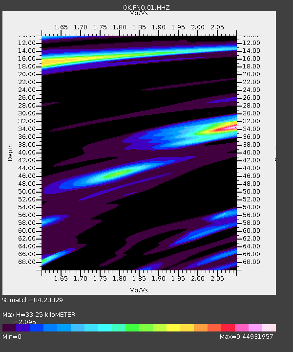
| Estimated Moho Depth: |
33.25 km |
| Estimated Crust Vp/Vs: |
2.10 |
| Assumed Crust Vp: |
6.426 km/s |
| Estimated Crust Vs: |
3.067 km/s |
| Estimated Crust Poisson's Ratio: |
0.35 |
|
| Radial Match: |
84.23329 % |
| Radial Bump: |
307 |
| Transverse Match: |
82.98967 % |
| Transverse Bump: |
302 |
| SOD ConfigId: |
2028011 |
| Insert Time: |
2017-05-15 12:43:13.364 +0000 |
| GWidth: |
2.5 |
| Max Bumps: |
400 |
| Tol: |
0.001 |
|

Signal To Noise
| Channel | StoN | STA | LTA |
| OK:FNO:01:HHZ:20170501T12:38:18.969003Z | 57.016804 | 8.203741E-6 | 1.4388286E-7 |
| OK:FNO:01:HHN:20170501T12:38:18.969003Z | 7.0068502 | 1.10778686E-7 | 1.5810054E-8 |
| OK:FNO:01:HHE:20170501T12:38:18.969003Z | 6.244603 | 2.410851E-6 | 3.860695E-7 |
| Arrivals |
| Ps | 6.0 SECOND |
| PpPs | 15 SECOND |
| PsPs/PpSs | 21 SECOND |


