You are here: Home > Network List > US - United States National Seismic Network Stations List
> Station GLMI Grayling, Michigan, USA > Earthquake Result Viewer
GLMI Grayling, Michigan, USA - Earthquake Result Viewer
| Earthquake location: |
Southeastern Alaska |
| Earthquake latitude/longitude: |
59.9/-136.6 |
| Earthquake time(UTC): |
2017/05/01 (121) 12:31:53 GMT |
| Earthquake Depth: |
0.1 km |
| Earthquake Magnitude: |
6.5 Ml |
| Earthquake Catalog/Contributor: |
NEIC PDE/ak |
|
| Network: |
US United States National Seismic Network |
| Station: |
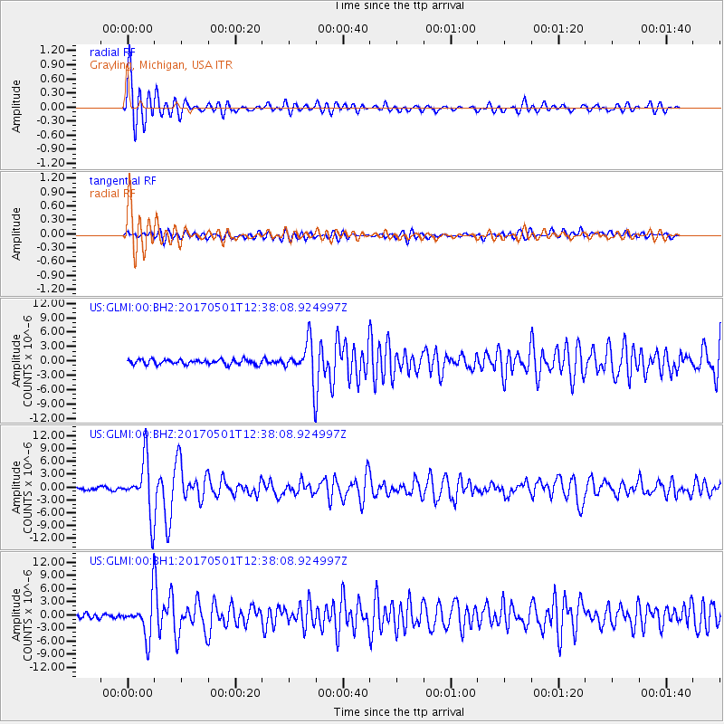
GLMI Grayling, Michigan, USA |
| Lat/Lon: |
44.82 N/84.62 W |
| Elevation: |
387 m |
|
| Distance: |
34.1 deg |
| Az: |
92.479 deg |
| Baz: |
314.901 deg |
| Ray Param: |
0.077915706 |
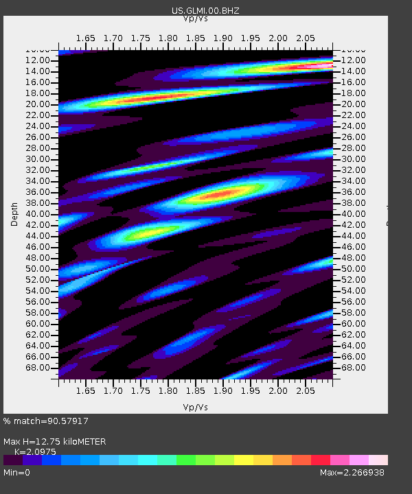
| Estimated Moho Depth: |
12.75 km |
| Estimated Crust Vp/Vs: |
2.10 |
| Assumed Crust Vp: |
6.483 km/s |
| Estimated Crust Vs: |
3.091 km/s |
| Estimated Crust Poisson's Ratio: |
0.35 |
|
| Radial Match: |
90.57917 % |
| Radial Bump: |
400 |
| Transverse Match: |
64.4289 % |
| Transverse Bump: |
400 |
| SOD ConfigId: |
2028011 |
| Insert Time: |
2017-05-15 12:44:14.777 +0000 |
| GWidth: |
2.5 |
| Max Bumps: |
400 |
| Tol: |
0.001 |
|
Signal To Noise
| Channel | StoN | STA | LTA |
| US:GLMI:00:BHZ:20170501T12:38:08.924997Z | 27.060816 | 6.3828743E-6 | 2.3587147E-7 |
| US:GLMI:00:BH1:20170501T12:38:08.924997Z | 11.215578 | 4.456008E-6 | 3.9730526E-7 |
| US:GLMI:00:BH2:20170501T12:38:08.924997Z | 7.7700315 | 4.020179E-6 | 5.1739545E-7 |
| Arrivals |
| Ps | 2.3 SECOND |
| PpPs | 5.7 SECOND |
| PsPs/PpSs | 8.0 SECOND |


