You are here: Home > Network List > US - United States National Seismic Network Stations List
> Station SCIA State Center, Iowa, USA > Earthquake Result Viewer
SCIA State Center, Iowa, USA - Earthquake Result Viewer
| Earthquake location: |
Southeastern Alaska |
| Earthquake latitude/longitude: |
59.9/-136.6 |
| Earthquake time(UTC): |
2017/05/01 (121) 12:31:53 GMT |
| Earthquake Depth: |
0.1 km |
| Earthquake Magnitude: |
6.5 Ml |
| Earthquake Catalog/Contributor: |
NEIC PDE/ak |
|
| Network: |
US United States National Seismic Network |
| Station: |
SCIA State Center, Iowa, USA |
| Lat/Lon: |
41.91 N/93.22 W |
| Elevation: |
312 m |
|
| Distance: |
32.0 deg |
| Az: |
104.543 deg |
| Baz: |
319.137 deg |
| Ray Param: |
0.07887389 |
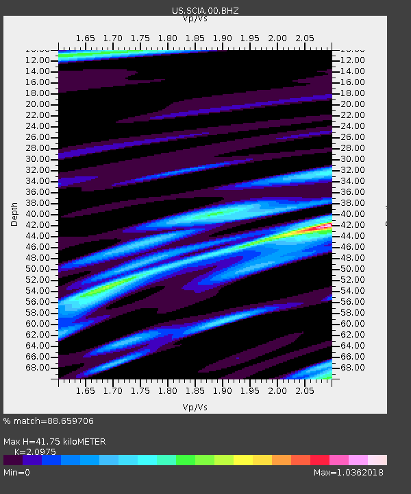
| Estimated Moho Depth: |
41.75 km |
| Estimated Crust Vp/Vs: |
2.10 |
| Assumed Crust Vp: |
6.498 km/s |
| Estimated Crust Vs: |
3.098 km/s |
| Estimated Crust Poisson's Ratio: |
0.35 |
|
| Radial Match: |
88.659706 % |
| Radial Bump: |
326 |
| Transverse Match: |
76.096825 % |
| Transverse Bump: |
355 |
| SOD ConfigId: |
2028011 |
| Insert Time: |
2017-05-15 12:45:24.454 +0000 |
| GWidth: |
2.5 |
| Max Bumps: |
400 |
| Tol: |
0.001 |
|
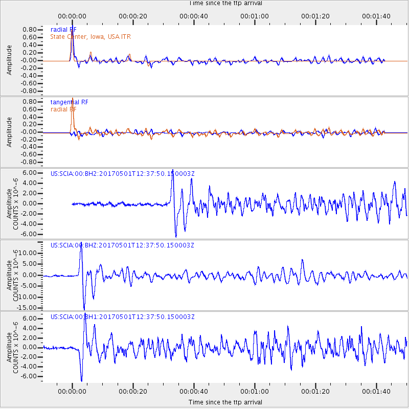
Signal To Noise
| Channel | StoN | STA | LTA |
| US:SCIA:00:BHZ:20170501T12:37:50.150003Z | 38.921772 | 6.8338536E-6 | 1.7557919E-7 |
| US:SCIA:00:BH1:20170501T12:37:50.150003Z | 21.625933 | 3.198884E-6 | 1.479189E-7 |
| US:SCIA:00:BH2:20170501T12:37:50.150003Z | 16.565332 | 2.936419E-6 | 1.772629E-7 |
| Arrivals |
| Ps | 7.6 SECOND |
| PpPs | 19 SECOND |
| PsPs/PpSs | 26 SECOND |


