You are here: Home > Network List > TA - USArray Transportable Network (new EarthScope stations) Stations List
> Station C16K Lisburne Hills, AK, USA > Earthquake Result Viewer
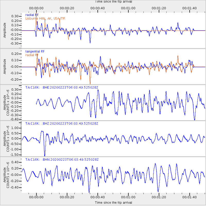
C16K Lisburne Hills, AK, USA - Earthquake Result Viewer
*The percent match for this event was below the threshold and hence no stack was calculated.
| Earthquake location: |
Turkey-Iran Border Region |
| Earthquake latitude/longitude: |
38.5/44.4 |
| Earthquake time(UTC): |
2020/02/23 (054) 05:53:01 GMT |
| Earthquake Depth: |
6.4 km |
| Earthquake Magnitude: |
5.7 mww |
| Earthquake Catalog/Contributor: |
NEIC PDE/us |
|
| Network: |
TA USArray Transportable Network (new EarthScope stations) |
| Station: |
C16K Lisburne Hills, AK, USA |
| Lat/Lon: |
68.27 N/165.34 W |
| Elevation: |
102 m |
|
| Distance: |
71.2 deg |
| Az: |
11.251 deg |
| Baz: |
335.721 deg |
| Ray Param: |
$rayparam |
*The percent match for this event was below the threshold and hence was not used in the summary stack. |
|
| Radial Match: |
65.07088 % |
| Radial Bump: |
400 |
| Transverse Match: |
62.41035 % |
| Transverse Bump: |
400 |
| SOD ConfigId: |
20831131 |
| Insert Time: |
2020-03-22 03:38:59.873 +0000 |
| GWidth: |
2.5 |
| Max Bumps: |
400 |
| Tol: |
0.001 |
|
Signal To Noise
| Channel | StoN | STA | LTA |
| TA:C16K: :BHZ:20200223T06:03:49.525028Z | 3.3066068 | 4.0625946E-7 | 1.2286296E-7 |
| TA:C16K: :BHN:20200223T06:03:49.525028Z | 1.0770307 | 1.12968884E-7 | 1.04889196E-7 |
| TA:C16K: :BHE:20200223T06:03:49.525028Z | 1.7697322 | 1.3398055E-7 | 7.570668E-8 |
| Arrivals |
| Ps | |
| PpPs | |
| PsPs/PpSs | |


