You are here: Home > Network List > GM - US Geological Survey Networks Stations List
> Station IWM01 Jericho 2M Well Monitoring Station > Earthquake Result Viewer
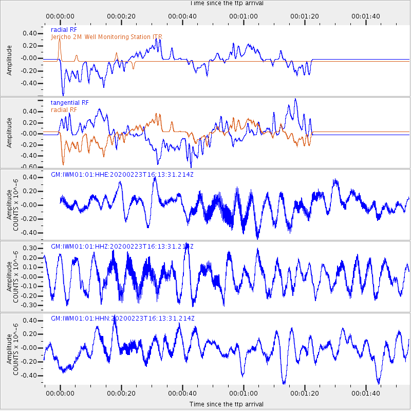
IWM01 Jericho 2M Well Monitoring Station - Earthquake Result Viewer
*The percent match for this event was below the threshold and hence no stack was calculated.
| Earthquake location: |
Turkey-Iran Border Region |
| Earthquake latitude/longitude: |
38.5/44.4 |
| Earthquake time(UTC): |
2020/02/23 (054) 16:00:31 GMT |
| Earthquake Depth: |
10 km |
| Earthquake Magnitude: |
6.0 mww |
| Earthquake Catalog/Contributor: |
NEIC PDE/us |
|
| Network: |
GM US Geological Survey Networks |
| Station: |
IWM01 Jericho 2M Well Monitoring Station |
| Lat/Lon: |
36.73 N/96.53 W |
| Elevation: |
328 m |
|
| Distance: |
96.9 deg |
| Az: |
329.308 deg |
| Baz: |
29.908 deg |
| Ray Param: |
$rayparam |
*The percent match for this event was below the threshold and hence was not used in the summary stack. |
|
| Radial Match: |
52.7516 % |
| Radial Bump: |
400 |
| Transverse Match: |
31.38423 % |
| Transverse Bump: |
400 |
| SOD ConfigId: |
20831131 |
| Insert Time: |
2020-03-23 12:56:47.474 +0000 |
| GWidth: |
2.5 |
| Max Bumps: |
400 |
| Tol: |
0.001 |
|
Signal To Noise
| Channel | StoN | STA | LTA |
| GM:IWM01:01:HHZ:20200223T16:13:31.214Z | 1.5543038 | 1.8004589E-7 | 1.15837E-7 |
| GM:IWM01:01:HHN:20200223T16:13:31.214Z | 2.1582513 | 3.2042928E-7 | 1.484671E-7 |
| GM:IWM01:01:HHE:20200223T16:13:31.214Z | 1.8743688 | 1.9788153E-7 | 1.05572354E-7 |
| Arrivals |
| Ps | |
| PpPs | |
| PsPs/PpSs | |


