You are here: Home > Network List > TX - Texas Seismological Network Stations List
> Station FW11 UT at Arlington > Earthquake Result Viewer
FW11 UT at Arlington - Earthquake Result Viewer
| Earthquake location: |
Southeastern Alaska |
| Earthquake latitude/longitude: |
59.9/-136.6 |
| Earthquake time(UTC): |
2017/05/01 (121) 12:31:53 GMT |
| Earthquake Depth: |
0.1 km |
| Earthquake Magnitude: |
6.5 Ml |
| Earthquake Catalog/Contributor: |
NEIC PDE/ak |
|
| Network: |
TX Texas Seismological Network |
| Station: |
FW11 UT at Arlington |
| Lat/Lon: |
32.72 N/97.13 W |
| Elevation: |
198 m |
|
| Distance: |
37.5 deg |
| Az: |
118.494 deg |
| Baz: |
328.262 deg |
| Ray Param: |
0.076107025 |
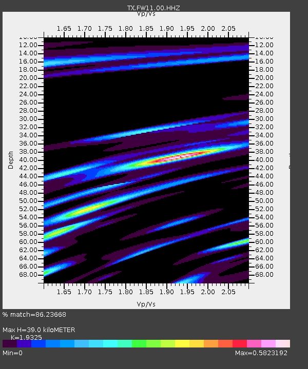
| Estimated Moho Depth: |
39.0 km |
| Estimated Crust Vp/Vs: |
1.93 |
| Assumed Crust Vp: |
6.38 km/s |
| Estimated Crust Vs: |
3.302 km/s |
| Estimated Crust Poisson's Ratio: |
0.32 |
|
| Radial Match: |
86.23668 % |
| Radial Bump: |
368 |
| Transverse Match: |
76.75615 % |
| Transverse Bump: |
400 |
| SOD ConfigId: |
2028011 |
| Insert Time: |
2017-05-15 12:47:26.321 +0000 |
| GWidth: |
2.5 |
| Max Bumps: |
400 |
| Tol: |
0.001 |
|
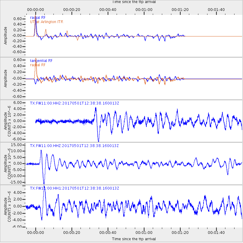
Signal To Noise
| Channel | StoN | STA | LTA |
| TX:FW11:00:HHZ:20170501T12:38:38.160013Z | 26.02585 | 6.3178236E-6 | 2.4275187E-7 |
| TX:FW11:00:HH1:20170501T12:38:38.160013Z | 7.063631 | 1.999992E-6 | 2.8313937E-7 |
| TX:FW11:00:HH2:20170501T12:38:38.160013Z | 7.598771 | 2.392728E-6 | 3.1488352E-7 |
| Arrivals |
| Ps | 6.1 SECOND |
| PpPs | 17 SECOND |
| PsPs/PpSs | 23 SECOND |


