You are here: Home > Network List > CI - Caltech Regional Seismic Network Stations List
> Station DAN Danby, California, USA > Earthquake Result Viewer
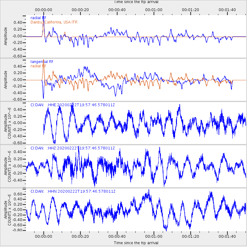
DAN Danby, California, USA - Earthquake Result Viewer
*The percent match for this event was below the threshold and hence no stack was calculated.
| Earthquake location: |
Tonga Islands |
| Earthquake latitude/longitude: |
-21.8/-174.7 |
| Earthquake time(UTC): |
2020/02/22 (053) 19:46:11 GMT |
| Earthquake Depth: |
10 km |
| Earthquake Magnitude: |
5.5 Mww |
| Earthquake Catalog/Contributor: |
NEIC PDE/us |
|
| Network: |
CI Caltech Regional Seismic Network |
| Station: |
DAN Danby, California, USA |
| Lat/Lon: |
34.64 N/115.38 W |
| Elevation: |
398 m |
|
| Distance: |
79.5 deg |
| Az: |
46.126 deg |
| Baz: |
234.325 deg |
| Ray Param: |
$rayparam |
*The percent match for this event was below the threshold and hence was not used in the summary stack. |
|
| Radial Match: |
54.124626 % |
| Radial Bump: |
400 |
| Transverse Match: |
38.92125 % |
| Transverse Bump: |
400 |
| SOD ConfigId: |
20831131 |
| Insert Time: |
2020-03-25 08:40:45.987 +0000 |
| GWidth: |
2.5 |
| Max Bumps: |
400 |
| Tol: |
0.001 |
|
Signal To Noise
| Channel | StoN | STA | LTA |
| CI:DAN: :HHZ:20200222T19:57:46.578011Z | 0.71164525 | 1.2548502E-7 | 1.7633086E-7 |
| CI:DAN: :HHN:20200222T19:57:46.578011Z | 1.6240603 | 3.2112672E-7 | 1.977308E-7 |
| CI:DAN: :HHE:20200222T19:57:46.578011Z | 0.5549642 | 1.6801236E-7 | 3.0274452E-7 |
| Arrivals |
| Ps | |
| PpPs | |
| PsPs/PpSs | |


