You are here: Home > Network List > TX - Texas Seismological Network Stations List
> Station POST Post > Earthquake Result Viewer
POST Post - Earthquake Result Viewer
| Earthquake location: |
Southeastern Alaska |
| Earthquake latitude/longitude: |
59.9/-136.6 |
| Earthquake time(UTC): |
2017/05/01 (121) 12:31:53 GMT |
| Earthquake Depth: |
0.1 km |
| Earthquake Magnitude: |
6.5 Ml |
| Earthquake Catalog/Contributor: |
NEIC PDE/ak |
|
| Network: |
TX Texas Seismological Network |
| Station: |
POST Post |
| Lat/Lon: |
33.07 N/101.50 W |
| Elevation: |
795 m |
|
| Distance: |
35.3 deg |
| Az: |
123.514 deg |
| Baz: |
329.936 deg |
| Ray Param: |
0.077293344 |
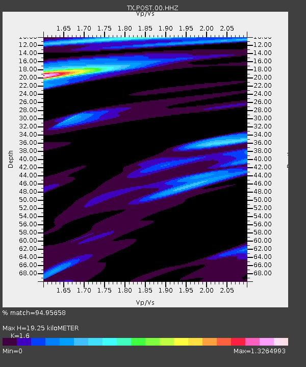
| Estimated Moho Depth: |
19.25 km |
| Estimated Crust Vp/Vs: |
1.60 |
| Assumed Crust Vp: |
6.426 km/s |
| Estimated Crust Vs: |
4.016 km/s |
| Estimated Crust Poisson's Ratio: |
0.18 |
|
| Radial Match: |
94.95658 % |
| Radial Bump: |
201 |
| Transverse Match: |
86.87355 % |
| Transverse Bump: |
382 |
| SOD ConfigId: |
2028011 |
| Insert Time: |
2017-05-15 12:48:06.387 +0000 |
| GWidth: |
2.5 |
| Max Bumps: |
400 |
| Tol: |
0.001 |
|

Signal To Noise
| Channel | StoN | STA | LTA |
| TX:POST:00:HHZ:20170501T12:38:19.544992Z | 49.219868 | 7.043978E-6 | 1.4311249E-7 |
| TX:POST:00:HH1:20170501T12:38:19.544992Z | 34.289814 | 4.1714234E-6 | 1.2165195E-7 |
| TX:POST:00:HH2:20170501T12:38:19.544992Z | 1.6149492 | 1.5068235E-7 | 9.33047E-8 |
| Arrivals |
| Ps | 2.0 SECOND |
| PpPs | 7.2 SECOND |
| PsPs/PpSs | 9.1 SECOND |


