You are here: Home > Network List > TA - USArray Transportable Network (new EarthScope stations) Stations List
> Station F26K Sheenjek River, AK, USA > Earthquake Result Viewer
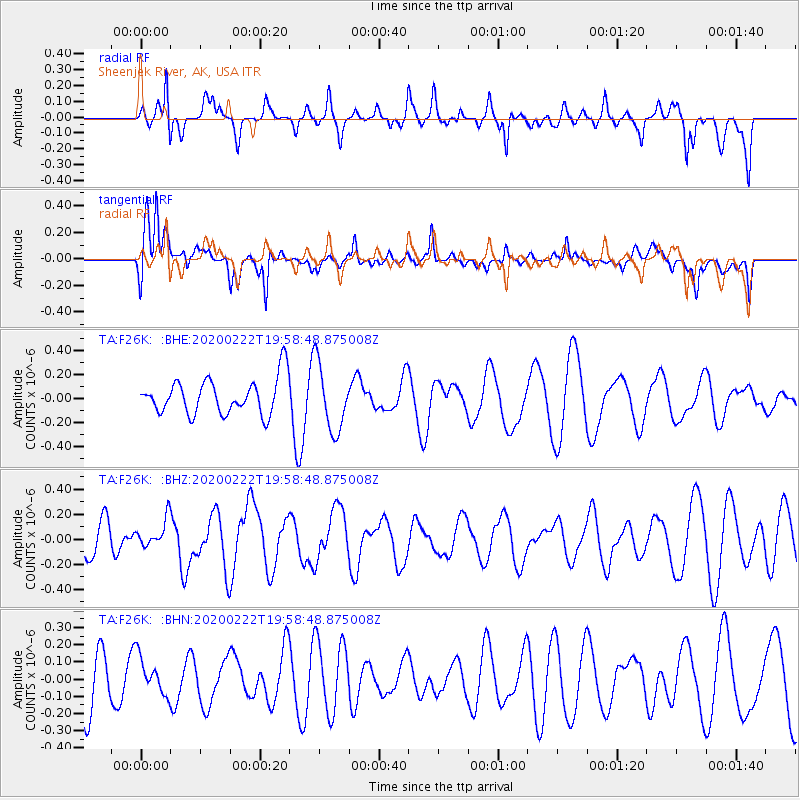
F26K Sheenjek River, AK, USA - Earthquake Result Viewer
*The percent match for this event was below the threshold and hence no stack was calculated.
| Earthquake location: |
Tonga Islands |
| Earthquake latitude/longitude: |
-21.8/-174.7 |
| Earthquake time(UTC): |
2020/02/22 (053) 19:46:11 GMT |
| Earthquake Depth: |
10 km |
| Earthquake Magnitude: |
5.5 Mww |
| Earthquake Catalog/Contributor: |
NEIC PDE/us |
|
| Network: |
TA USArray Transportable Network (new EarthScope stations) |
| Station: |
F26K Sheenjek River, AK, USA |
| Lat/Lon: |
67.69 N/144.15 W |
| Elevation: |
683 m |
|
| Distance: |
92.1 deg |
| Az: |
11.181 deg |
| Baz: |
208.164 deg |
| Ray Param: |
$rayparam |
*The percent match for this event was below the threshold and hence was not used in the summary stack. |
|
| Radial Match: |
52.674717 % |
| Radial Bump: |
335 |
| Transverse Match: |
72.6469 % |
| Transverse Bump: |
400 |
| SOD ConfigId: |
20831131 |
| Insert Time: |
2020-03-25 10:49:40.650 +0000 |
| GWidth: |
2.5 |
| Max Bumps: |
400 |
| Tol: |
0.001 |
|
Signal To Noise
| Channel | StoN | STA | LTA |
| TA:F26K: :BHZ:20200222T19:58:48.875008Z | 0.808386 | 1.1045511E-7 | 1.366366E-7 |
| TA:F26K: :BHN:20200222T19:58:48.875008Z | 0.89009345 | 1.0918679E-7 | 1.2266891E-7 |
| TA:F26K: :BHE:20200222T19:58:48.875008Z | 1.8906924 | 2.7942204E-7 | 1.4778821E-7 |
| Arrivals |
| Ps | |
| PpPs | |
| PsPs/PpSs | |


