You are here: Home > Network List > II - Global Seismograph Network (GSN - IRIS/IDA) Stations List
> Station ABPO Ambohimpanompo, Madagascar > Earthquake Result Viewer
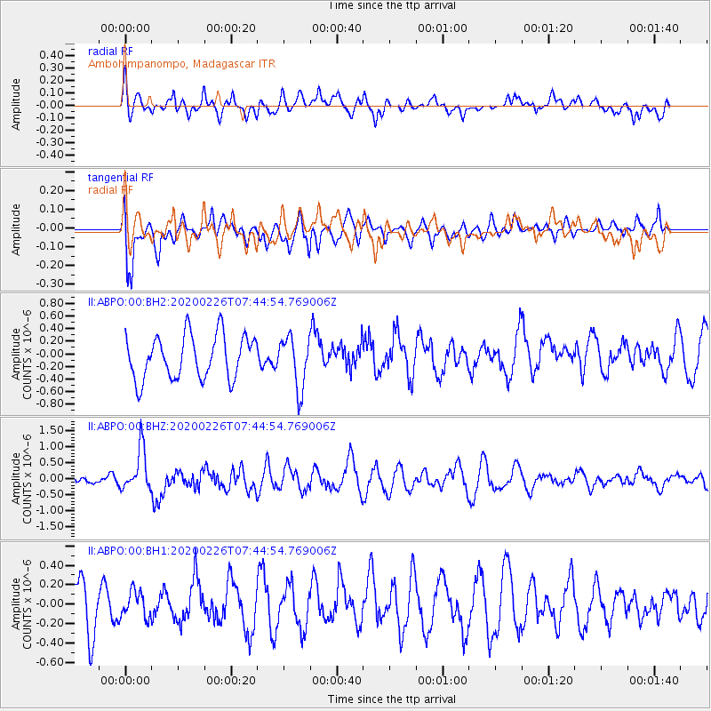
ABPO Ambohimpanompo, Madagascar - Earthquake Result Viewer
*The percent match for this event was below the threshold and hence no stack was calculated.
| Earthquake location: |
Tanimbar Islands Reg., Indonesia |
| Earthquake latitude/longitude: |
-7.6/131.1 |
| Earthquake time(UTC): |
2020/02/26 (057) 07:33:13 GMT |
| Earthquake Depth: |
61 km |
| Earthquake Magnitude: |
5.9 Mww |
| Earthquake Catalog/Contributor: |
NEIC PDE/us |
|
| Network: |
II Global Seismograph Network (GSN - IRIS/IDA) |
| Station: |
ABPO Ambohimpanompo, Madagascar |
| Lat/Lon: |
19.02 S/47.23 E |
| Elevation: |
1528 m |
|
| Distance: |
81.8 deg |
| Az: |
251.873 deg |
| Baz: |
95.189 deg |
| Ray Param: |
$rayparam |
*The percent match for this event was below the threshold and hence was not used in the summary stack. |
|
| Radial Match: |
45.31266 % |
| Radial Bump: |
400 |
| Transverse Match: |
58.741673 % |
| Transverse Bump: |
400 |
| SOD ConfigId: |
20831131 |
| Insert Time: |
2020-03-26 15:25:30.787 +0000 |
| GWidth: |
2.5 |
| Max Bumps: |
400 |
| Tol: |
0.001 |
|
Signal To Noise
| Channel | StoN | STA | LTA |
| II:ABPO:00:BHZ:20200226T07:44:54.769006Z | 2.851239 | 6.66504E-7 | 2.3375941E-7 |
| II:ABPO:00:BH1:20200226T07:44:54.769006Z | 0.6121321 | 1.3496076E-7 | 2.2047652E-7 |
| II:ABPO:00:BH2:20200226T07:44:54.769006Z | 1.1932979 | 4.1283158E-7 | 3.4595854E-7 |
| Arrivals |
| Ps | |
| PpPs | |
| PsPs/PpSs | |


