You are here: Home > Network List > IU - Global Seismograph Network (GSN - IRIS/USGS) Stations List
> Station ULN Ulaanbaatar, Mongolia > Earthquake Result Viewer
ULN Ulaanbaatar, Mongolia - Earthquake Result Viewer
*The percent match for this event was below the threshold and hence no stack was calculated.
| Earthquake location: |
Tanimbar Islands Reg., Indonesia |
| Earthquake latitude/longitude: |
-7.6/131.1 |
| Earthquake time(UTC): |
2020/02/26 (057) 07:33:13 GMT |
| Earthquake Depth: |
61 km |
| Earthquake Magnitude: |
5.9 Mww |
| Earthquake Catalog/Contributor: |
NEIC PDE/us |
|
| Network: |
IU Global Seismograph Network (GSN - IRIS/USGS) |
| Station: |
ULN Ulaanbaatar, Mongolia |
| Lat/Lon: |
47.87 N/107.05 E |
| Elevation: |
1610 m |
|
| Distance: |
59.1 deg |
| Az: |
341.345 deg |
| Baz: |
151.904 deg |
| Ray Param: |
$rayparam |
*The percent match for this event was below the threshold and hence was not used in the summary stack. |
|
| Radial Match: |
79.25138 % |
| Radial Bump: |
400 |
| Transverse Match: |
67.06761 % |
| Transverse Bump: |
400 |
| SOD ConfigId: |
20831131 |
| Insert Time: |
2020-03-26 15:31:06.375 +0000 |
| GWidth: |
2.5 |
| Max Bumps: |
400 |
| Tol: |
0.001 |
|
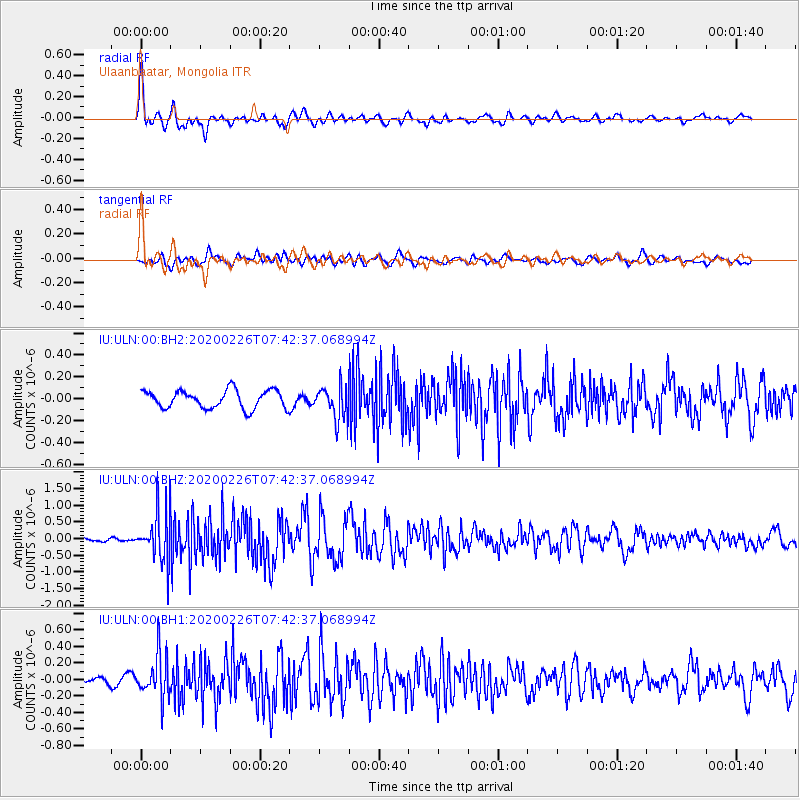
Signal To Noise
| Channel | StoN | STA | LTA |
| IU:ULN:00:BHZ:20200226T07:42:37.068994Z | 12.610944 | 7.3670736E-7 | 5.8418102E-8 |
| IU:ULN:00:BH1:20200226T07:42:37.068994Z | 6.437768 | 2.6201087E-7 | 4.0699025E-8 |
| IU:ULN:00:BH2:20200226T07:42:37.068994Z | 1.8243724 | 1.5002601E-7 | 8.2234315E-8 |
| Arrivals |
| Ps | |
| PpPs | |
| PsPs/PpSs | |


