You are here: Home > Network List > TJ - Tajikistan National Seismic Network Stations List
> Station SHAA Shaartuz, Tajikistan > Earthquake Result Viewer
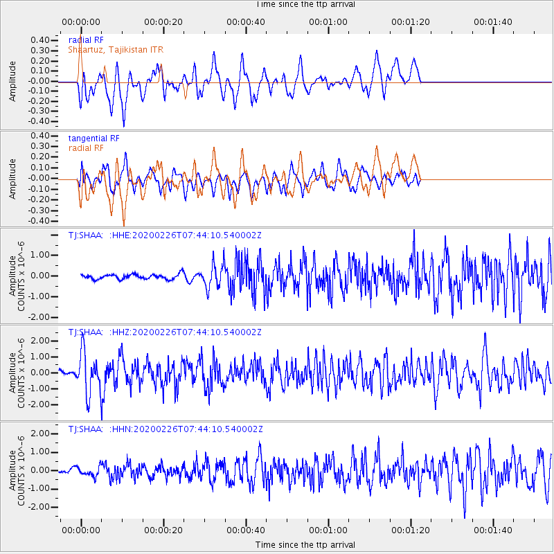
SHAA Shaartuz, Tajikistan - Earthquake Result Viewer
*The percent match for this event was below the threshold and hence no stack was calculated.
| Earthquake location: |
Tanimbar Islands Reg., Indonesia |
| Earthquake latitude/longitude: |
-7.6/131.1 |
| Earthquake time(UTC): |
2020/02/26 (057) 07:33:13 GMT |
| Earthquake Depth: |
61 km |
| Earthquake Magnitude: |
5.9 Mww |
| Earthquake Catalog/Contributor: |
NEIC PDE/us |
|
| Network: |
TJ Tajikistan National Seismic Network |
| Station: |
SHAA Shaartuz, Tajikistan |
| Lat/Lon: |
37.56 N/68.12 E |
| Elevation: |
868 m |
|
| Distance: |
73.8 deg |
| Az: |
312.509 deg |
| Baz: |
113.121 deg |
| Ray Param: |
$rayparam |
*The percent match for this event was below the threshold and hence was not used in the summary stack. |
|
| Radial Match: |
61.783104 % |
| Radial Bump: |
400 |
| Transverse Match: |
55.146084 % |
| Transverse Bump: |
400 |
| SOD ConfigId: |
20831131 |
| Insert Time: |
2020-03-26 16:03:24.801 +0000 |
| GWidth: |
2.5 |
| Max Bumps: |
400 |
| Tol: |
0.001 |
|
Signal To Noise
| Channel | StoN | STA | LTA |
| TJ:SHAA: :HHZ:20200226T07:44:10.540002Z | 6.972531 | 1.3065011E-6 | 1.8737832E-7 |
| TJ:SHAA: :HHN:20200226T07:44:10.540002Z | 1.3623345 | 2.4708007E-7 | 1.813652E-7 |
| TJ:SHAA: :HHE:20200226T07:44:10.540002Z | 4.9138627 | 5.798889E-7 | 1.1801079E-7 |
| Arrivals |
| Ps | |
| PpPs | |
| PsPs/PpSs | |


