You are here: Home > Network List > AV - Alaska Volcano Observatory Stations List
> Station SPCR Ckakachatna River, Mount Spurr, Alaska > Earthquake Result Viewer
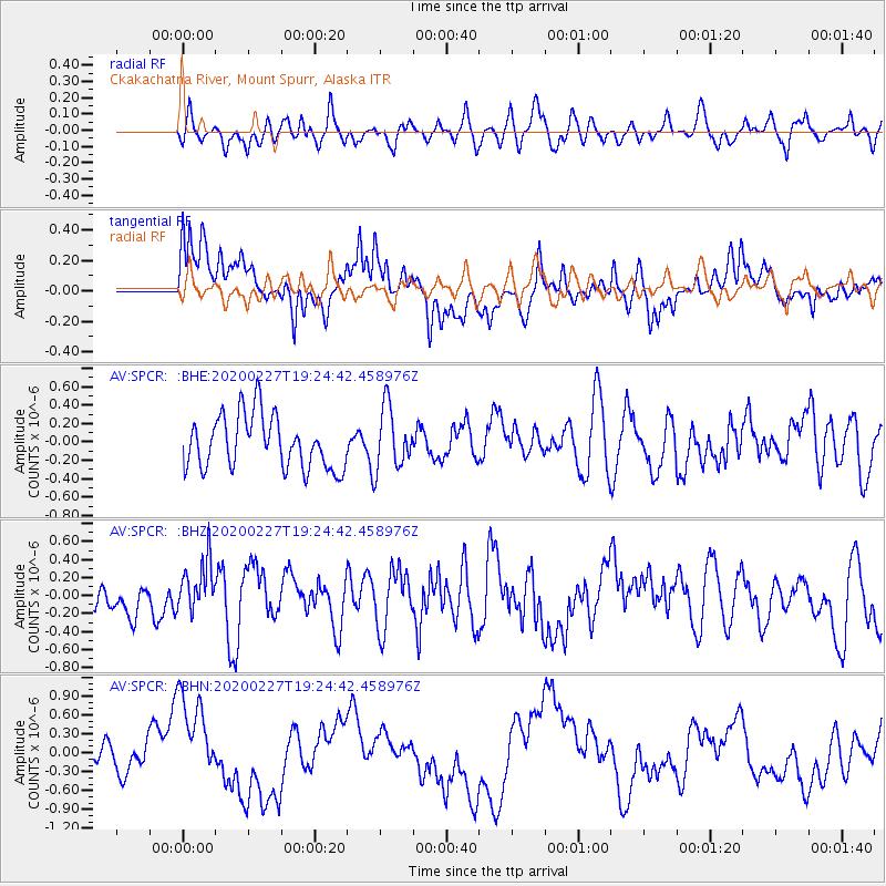
SPCR Ckakachatna River, Mount Spurr, Alaska - Earthquake Result Viewer
*The percent match for this event was below the threshold and hence no stack was calculated.
| Earthquake location: |
Talaud Islands, Indonesia |
| Earthquake latitude/longitude: |
3.8/125.8 |
| Earthquake time(UTC): |
2020/02/27 (058) 19:13:02 GMT |
| Earthquake Depth: |
122 km |
| Earthquake Magnitude: |
5.5 Mww |
| Earthquake Catalog/Contributor: |
NEIC PDE/us |
|
| Network: |
AV Alaska Volcano Observatory |
| Station: |
SPCR Ckakachatna River, Mount Spurr, Alaska |
| Lat/Lon: |
61.20 N/152.21 W |
| Elevation: |
984 m |
|
| Distance: |
82.8 deg |
| Az: |
28.903 deg |
| Baz: |
264.835 deg |
| Ray Param: |
$rayparam |
*The percent match for this event was below the threshold and hence was not used in the summary stack. |
|
| Radial Match: |
45.16073 % |
| Radial Bump: |
400 |
| Transverse Match: |
52.484875 % |
| Transverse Bump: |
400 |
| SOD ConfigId: |
20831131 |
| Insert Time: |
2020-03-27 13:17:05.131 +0000 |
| GWidth: |
2.5 |
| Max Bumps: |
400 |
| Tol: |
0.001 |
|
Signal To Noise
| Channel | StoN | STA | LTA |
| AV:SPCR: :BHZ:20200227T19:24:42.458976Z | 1.1518406 | 2.9022024E-7 | 2.5196218E-7 |
| AV:SPCR: :BHN:20200227T19:24:42.458976Z | 2.317001 | 7.3017685E-7 | 3.1513875E-7 |
| AV:SPCR: :BHE:20200227T19:24:42.458976Z | 1.1500089 | 3.3180916E-7 | 2.8852745E-7 |
| Arrivals |
| Ps | |
| PpPs | |
| PsPs/PpSs | |


