You are here: Home > Network List > IW - Intermountain West Stations List
> Station DLMT Dillon, Montana, USA > Earthquake Result Viewer
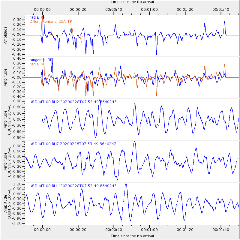
DLMT Dillon, Montana, USA - Earthquake Result Viewer
*The percent match for this event was below the threshold and hence no stack was calculated.
| Earthquake location: |
Tonga Islands Region |
| Earthquake latitude/longitude: |
-18.9/-172.9 |
| Earthquake time(UTC): |
2020/02/28 (059) 07:41:50 GMT |
| Earthquake Depth: |
10 km |
| Earthquake Magnitude: |
5.8 Mww |
| Earthquake Catalog/Contributor: |
NEIC PDE/us |
|
| Network: |
IW Intermountain West |
| Station: |
DLMT Dillon, Montana, USA |
| Lat/Lon: |
45.36 N/112.60 W |
| Elevation: |
1569 m |
|
| Distance: |
84.1 deg |
| Az: |
38.009 deg |
| Baz: |
235.789 deg |
| Ray Param: |
$rayparam |
*The percent match for this event was below the threshold and hence was not used in the summary stack. |
|
| Radial Match: |
43.426006 % |
| Radial Bump: |
335 |
| Transverse Match: |
59.635185 % |
| Transverse Bump: |
400 |
| SOD ConfigId: |
20883691 |
| Insert Time: |
2020-03-29 08:56:42.135 +0000 |
| GWidth: |
2.5 |
| Max Bumps: |
400 |
| Tol: |
0.001 |
|
Signal To Noise
| Channel | StoN | STA | LTA |
| IW:DLMT:00:BHZ:20200228T07:53:49.864024Z | 1.0717835 | 1.6226544E-7 | 1.5139759E-7 |
| IW:DLMT:00:BH1:20200228T07:53:49.864024Z | 1.6986073 | 5.137186E-7 | 3.0243515E-7 |
| IW:DLMT:00:BH2:20200228T07:53:49.864024Z | 1.9285283 | 6.381135E-7 | 3.3088105E-7 |
| Arrivals |
| Ps | |
| PpPs | |
| PsPs/PpSs | |


