You are here: Home > Network List > TA - USArray Transportable Network (new EarthScope stations) Stations List
> Station E20K Nigu River, AK, USA > Earthquake Result Viewer
E20K Nigu River, AK, USA - Earthquake Result Viewer
| Earthquake location: |
Tonga Islands Region |
| Earthquake latitude/longitude: |
-18.9/-172.9 |
| Earthquake time(UTC): |
2020/02/28 (059) 07:41:50 GMT |
| Earthquake Depth: |
10 km |
| Earthquake Magnitude: |
5.8 Mww |
| Earthquake Catalog/Contributor: |
NEIC PDE/us |
|
| Network: |
TA USArray Transportable Network (new EarthScope stations) |
| Station: |
E20K Nigu River, AK, USA |
| Lat/Lon: |
68.26 N/156.19 W |
| Elevation: |
866 m |
|
| Distance: |
87.8 deg |
| Az: |
6.164 deg |
| Baz: |
195.834 deg |
| Ray Param: |
0.043095496 |
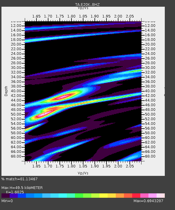
| Estimated Moho Depth: |
49.5 km |
| Estimated Crust Vp/Vs: |
1.68 |
| Assumed Crust Vp: |
6.221 km/s |
| Estimated Crust Vs: |
3.698 km/s |
| Estimated Crust Poisson's Ratio: |
0.23 |
|
| Radial Match: |
81.13467 % |
| Radial Bump: |
282 |
| Transverse Match: |
51.90182 % |
| Transverse Bump: |
378 |
| SOD ConfigId: |
20883691 |
| Insert Time: |
2020-03-29 10:08:56.095 +0000 |
| GWidth: |
2.5 |
| Max Bumps: |
400 |
| Tol: |
0.001 |
|

Signal To Noise
| Channel | StoN | STA | LTA |
| TA:E20K: :BHZ:20200228T07:54:07.700023Z | 1.3447545 | 1.7166913E-7 | 1.2765834E-7 |
| TA:E20K: :BHN:20200228T07:54:07.700023Z | 2.3080196 | 2.421546E-7 | 1.0491878E-7 |
| TA:E20K: :BHE:20200228T07:54:07.700023Z | 0.8366141 | 7.974707E-8 | 9.532121E-8 |
| Arrivals |
| Ps | 5.6 SECOND |
| PpPs | 21 SECOND |
| PsPs/PpSs | 26 SECOND |


