You are here: Home > Network List > SP - South Carolina Earth Physics Project Stations List
> Station DWDAN D.W. Daniels High School, Pickens County, SC USA > Earthquake Result Viewer
DWDAN D.W. Daniels High School, Pickens County, SC USA - Earthquake Result Viewer

| Earthquake location: |
Northwest Of Kuril Islands |
| Earthquake latitude/longitude: |
47.8/146.2 |
| Earthquake time(UTC): |
2002/11/17 (321) 04:53:53 GMT |
| Earthquake Depth: |
459 km |
| Earthquake Magnitude: |
7.3 MW, 7.3 MW |
| Earthquake Catalog/Contributor: |
WHDF/NEIC |
|
| Network: |
SP South Carolina Earth Physics Project |
| Station: |
DWDAN D.W. Daniels High School, Pickens County, SC USA |
| Lat/Lon: |
34.74 N/82.83 W |
| Elevation: |
286 m |
|
| Distance: |
86.8 deg |
| Az: |
38.526 deg |
| Baz: |
329.358 deg |
| Ray Param: |
0.042527985 |
| Estimated Moho Depth: |
44.75 km |
| Estimated Crust Vp/Vs: |
1.75 |
| Assumed Crust Vp: |
6.35 km/s |
| Estimated Crust Vs: |
3.618 km/s |
| Estimated Crust Poisson's Ratio: |
0.26 |
|
| Radial Match: |
91.45737 % |
| Radial Bump: |
381 |
| Transverse Match: |
82.52375 % |
| Transverse Bump: |
388 |
| SOD ConfigId: |
2049 |
| Insert Time: |
2010-02-25 16:11:32.863 +0000 |
| GWidth: |
2.5 |
| Max Bumps: |
400 |
| Tol: |
0.001 |
|
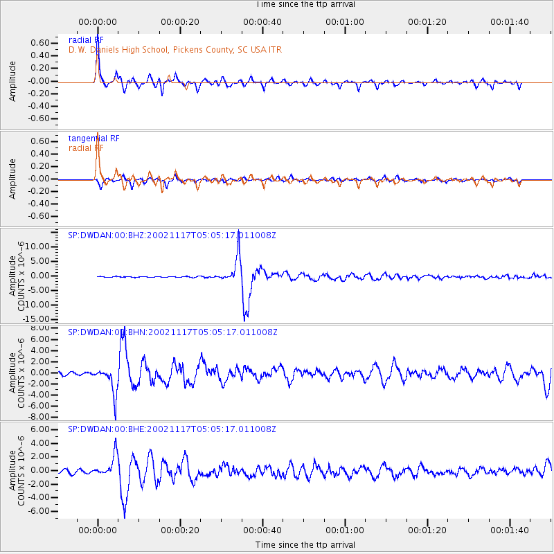
Signal To Noise
| Channel | StoN | STA | LTA |
| SP:DWDAN:00:BHN:20021117T05:05:17.011008Z | 14.277369 | 2.48976E-6 | 1.7438506E-7 |
| SP:DWDAN:00:BHE:20021117T05:05:17.011008Z | 8.3998995 | 1.6734278E-6 | 1.9921997E-7 |
| SP:DWDAN:00:BHZ:20021117T05:05:17.011008Z | 31.95783 | 4.891261E-6 | 1.530536E-7 |
| Arrivals |
| Ps | 5.4 SECOND |
| PpPs | 19 SECOND |
| PsPs/PpSs | 24 SECOND |


