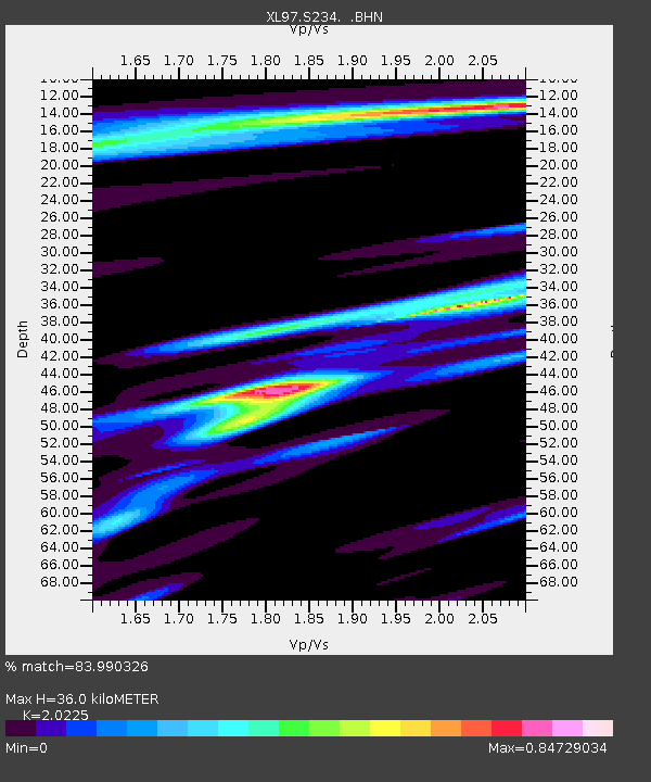
S234 Frontage Road - Earthquake Result Viewer

Earthquake location: Kermadec Islands Region
Earthquake latitude/longitude: -28.7/-177.6
Earthquake time(UTC): 1997/09/20 (263) 16:11:32 GMT
Earthquake Depth: 30 km
Earthquake Magnitude: 6.1 MB, 7.0 MS, 7.2 UNKNOWN, 6.7 ME
Earthquake Catalog/Contributor: WHDF/NEIC
Network: XL Deep Probe (Archean-Proterozoic)
Station: S234 Frontage Road
Lat/Lon: 39.36 N/108.15 W
Elevation: 1509 m
Distance: 93.6 deg
Az: 46.674 deg
Baz: 235.535 deg
Ray Param: 0.04121989
Estimated Moho Depth: 36.0 km
Estimated Crust Vp/Vs: 2.02
Assumed Crust Vp: 6.291 km/s
Estimated Crust Vs: 3.11 km/s
Estimated Crust Poisson's Ratio: 0.34
Radial Match: 83.990326 %
Radial Bump: 400
Transverse Match: 68.30379 %
Transverse Bump: 400
SOD ConfigId: 6273
Insert Time: 2010-03-08 18:09:00.171 +0000
GWidth: 2.5
Max Bumps: 400
Tol: 0.001

Signal To Noise

ChannelStoNSTALTA
XL:S234: :BHN:19970920T16:24:13.943018Z2.63587474.644211E-71.761924E-7
XL:S234: :BHE:19970920T16:24:13.943018Z2.48900873.2978235E-71.3249546E-7
XL:S234: :BHZ:19970920T16:24:13.943018Z7.1557241.1659108E-61.6293401E-7
Arrivals
Ps6.0 SECOND
PpPs17 SECOND
PsPs/PpSs23 SECOND