You are here: Home > Network List > US - United States National Seismic Network Stations List
> Station MNTX Cornudas Mountains, Texas, USA > Earthquake Result Viewer
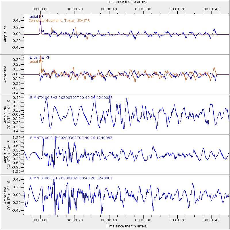
MNTX Cornudas Mountains, Texas, USA - Earthquake Result Viewer
*The percent match for this event was below the threshold and hence no stack was calculated.
| Earthquake location: |
Andreanof Islands, Aleutian Is. |
| Earthquake latitude/longitude: |
51.1/-179.9 |
| Earthquake time(UTC): |
2020/03/02 (062) 00:31:16 GMT |
| Earthquake Depth: |
24 km |
| Earthquake Magnitude: |
5.7 mww |
| Earthquake Catalog/Contributor: |
NEIC PDE/us |
|
| Network: |
US United States National Seismic Network |
| Station: |
MNTX Cornudas Mountains, Texas, USA |
| Lat/Lon: |
31.70 N/105.38 W |
| Elevation: |
404 m |
|
| Distance: |
56.6 deg |
| Az: |
79.5 deg |
| Baz: |
313.382 deg |
| Ray Param: |
$rayparam |
*The percent match for this event was below the threshold and hence was not used in the summary stack. |
|
| Radial Match: |
68.20049 % |
| Radial Bump: |
400 |
| Transverse Match: |
59.404797 % |
| Transverse Bump: |
400 |
| SOD ConfigId: |
20883691 |
| Insert Time: |
2020-03-31 18:59:29.011 +0000 |
| GWidth: |
2.5 |
| Max Bumps: |
400 |
| Tol: |
0.001 |
|
Signal To Noise
| Channel | StoN | STA | LTA |
| US:MNTX:00:BHZ:20200302T00:40:26.124008Z | 2.3792868 | 4.016019E-7 | 1.6879088E-7 |
| US:MNTX:00:BH1:20200302T00:40:26.124008Z | 1.1174371 | 1.5800809E-7 | 1.4140221E-7 |
| US:MNTX:00:BH2:20200302T00:40:26.124008Z | 1.3743472 | 2.2551342E-7 | 1.6408767E-7 |
| Arrivals |
| Ps | |
| PpPs | |
| PsPs/PpSs | |


