You are here: Home > Network List > UW - Pacific Northwest Regional Seismic Network Stations List
> Station HOOD Mt Hood Meadows, OR CREST BB SMO > Earthquake Result Viewer
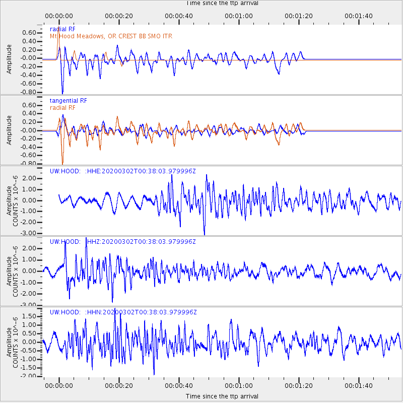
HOOD Mt Hood Meadows, OR CREST BB SMO - Earthquake Result Viewer
*The percent match for this event was below the threshold and hence no stack was calculated.
| Earthquake location: |
Andreanof Islands, Aleutian Is. |
| Earthquake latitude/longitude: |
51.1/-179.9 |
| Earthquake time(UTC): |
2020/03/02 (062) 00:31:16 GMT |
| Earthquake Depth: |
24 km |
| Earthquake Magnitude: |
5.7 mww |
| Earthquake Catalog/Contributor: |
NEIC PDE/us |
|
| Network: |
UW Pacific Northwest Regional Seismic Network |
| Station: |
HOOD Mt Hood Meadows, OR CREST BB SMO |
| Lat/Lon: |
45.32 N/121.65 W |
| Elevation: |
1520 m |
|
| Distance: |
38.3 deg |
| Az: |
75.255 deg |
| Baz: |
300.271 deg |
| Ray Param: |
$rayparam |
*The percent match for this event was below the threshold and hence was not used in the summary stack. |
|
| Radial Match: |
68.93884 % |
| Radial Bump: |
400 |
| Transverse Match: |
62.080757 % |
| Transverse Bump: |
400 |
| SOD ConfigId: |
20883691 |
| Insert Time: |
2020-03-31 19:07:16.144 +0000 |
| GWidth: |
2.5 |
| Max Bumps: |
400 |
| Tol: |
0.001 |
|
Signal To Noise
| Channel | StoN | STA | LTA |
| UW:HOOD: :HHZ:20200302T00:38:03.979996Z | 2.4924614 | 1.0153828E-6 | 4.0738155E-7 |
| UW:HOOD: :HHN:20200302T00:38:03.979996Z | 1.8771186 | 4.1685317E-7 | 2.2207075E-7 |
| UW:HOOD: :HHE:20200302T00:38:03.979996Z | 1.227267 | 5.0726896E-7 | 4.133322E-7 |
| Arrivals |
| Ps | |
| PpPs | |
| PsPs/PpSs | |


