You are here: Home > Network List > US - United States National Seismic Network Stations List
> Station AMTX Amarillo, Texas, USA > Earthquake Result Viewer
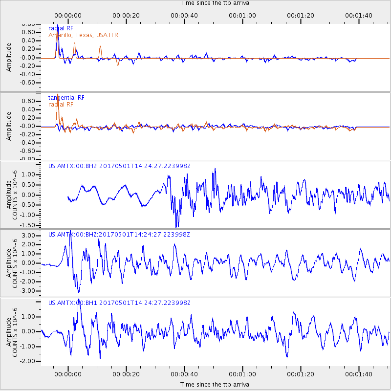
AMTX Amarillo, Texas, USA - Earthquake Result Viewer
*The percent match for this event was below the threshold and hence no stack was calculated.
| Earthquake location: |
Southeastern Alaska |
| Earthquake latitude/longitude: |
59.8/-136.6 |
| Earthquake time(UTC): |
2017/05/01 (121) 14:18:15 GMT |
| Earthquake Depth: |
3.3 km |
| Earthquake Magnitude: |
6.3 Ml |
| Earthquake Catalog/Contributor: |
NEIC PDE/ak |
|
| Network: |
US United States National Seismic Network |
| Station: |
AMTX Amarillo, Texas, USA |
| Lat/Lon: |
34.53 N/101.41 W |
| Elevation: |
1010 m |
|
| Distance: |
34.1 deg |
| Az: |
122.0 deg |
| Baz: |
328.766 deg |
| Ray Param: |
$rayparam |
*The percent match for this event was below the threshold and hence was not used in the summary stack. |
|
| Radial Match: |
88.71819 % |
| Radial Bump: |
274 |
| Transverse Match: |
56.639004 % |
| Transverse Bump: |
400 |
| SOD ConfigId: |
2028011 |
| Insert Time: |
2017-05-15 14:30:09.390 +0000 |
| GWidth: |
2.5 |
| Max Bumps: |
400 |
| Tol: |
0.001 |
|
Signal To Noise
| Channel | StoN | STA | LTA |
| US:AMTX:00:BHZ:20170501T14:24:27.223998Z | 19.081438 | 1.9996055E-6 | 1.0479323E-7 |
| US:AMTX:00:BH1:20170501T14:24:27.223998Z | 6.5816927 | 1.1001276E-6 | 1.6714965E-7 |
| US:AMTX:00:BH2:20170501T14:24:27.223998Z | 2.5716896 | 7.88497E-7 | 3.0660658E-7 |
| Arrivals |
| Ps | |
| PpPs | |
| PsPs/PpSs | |


