You are here: Home > Network List > UW - Pacific Northwest Regional Seismic Network Stations List
> Station UMAT Pilot Rock, OR, USA > Earthquake Result Viewer
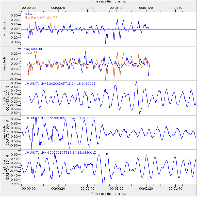
UMAT Pilot Rock, OR, USA - Earthquake Result Viewer
*The percent match for this event was below the threshold and hence no stack was calculated.
| Earthquake location: |
Kermadec Islands Region |
| Earthquake latitude/longitude: |
-29.8/-176.3 |
| Earthquake time(UTC): |
2020/03/05 (065) 13:11:46 GMT |
| Earthquake Depth: |
10 km |
| Earthquake Magnitude: |
5.6 mb |
| Earthquake Catalog/Contributor: |
NEIC PDE/us |
|
| Network: |
UW Pacific Northwest Regional Seismic Network |
| Station: |
UMAT Pilot Rock, OR, USA |
| Lat/Lon: |
45.29 N/118.96 W |
| Elevation: |
1318 m |
|
| Distance: |
91.1 deg |
| Az: |
36.453 deg |
| Baz: |
227.039 deg |
| Ray Param: |
$rayparam |
*The percent match for this event was below the threshold and hence was not used in the summary stack. |
|
| Radial Match: |
65.55879 % |
| Radial Bump: |
400 |
| Transverse Match: |
53.07831 % |
| Transverse Bump: |
400 |
| SOD ConfigId: |
20883691 |
| Insert Time: |
2020-04-04 19:10:13.042 +0000 |
| GWidth: |
2.5 |
| Max Bumps: |
400 |
| Tol: |
0.001 |
|
Signal To Noise
| Channel | StoN | STA | LTA |
| UW:UMAT: :HHZ:20200305T13:24:18.948001Z | 2.0934532 | 5.226994E-7 | 2.4968287E-7 |
| UW:UMAT: :HHN:20200305T13:24:18.948001Z | 1.1515286 | 2.522508E-7 | 2.1905736E-7 |
| UW:UMAT: :HHE:20200305T13:24:18.948001Z | 0.8490505 | 2.0324305E-7 | 2.3937687E-7 |
| Arrivals |
| Ps | |
| PpPs | |
| PsPs/PpSs | |


